
Recherchez sur le site !
Recherche avancée / SpécifiqueCatégories publications
+ Sciences De La Terre - Archéologie - Astronomie - Spéléologie - Ecologie - Pédologie - Volcanologie - L'hydrogéologie - Géomorphologie - Minéralogie - Pétrologie - Paléontologie - Géologie + Climatologie - Réchouffement climatique - Changement climatique + Plantes - Plantes Aromatiques - Plantes médicinales + Zoologie - Faunes + Botanique - Flors + Sciences humaines - Géo Eco Tourisme - L’anthropologie - L'Histoire - Démographie - Sociologie - Géographie - Patrimoine culturel
Géo éco tourisme inclusif

Géoparc et Recherche Scientifique
Le coins de l’étudiant


Blog Géoparc Jbel Bani

Geomorphosites of the Semi-arid Tata Region: Valorization of an Unknown Geoheritage for Geotourism Sustainable Development (Anti-Atlas, South Morocco) (Géoparc Jbel Bani)
Sanae Berred & Driss Fadli & Mohammed El Wartiti & Mohammed Zahraoui & Khadija Berred & Ridouane Sadki
Received: 7 February 2019 /Accepted: 24 September 2019
#the European Association for Conservation of the Geological Heritage 2019
Abstract
The Tata region is locate in the South Western Anti-Atlas. It consists of Paléoprotérozoïque to Quaternary age fields. These fields, affected by several geodynamic events, have been exposed to long periods of erosion, adding to climate hostility to make the geology and geomorphology of the Anti-Atlas easier to read and more fascinating to contemplate, compared to other geological domains of Morocco. The superimposition of the different orogeneses is materialized by several geological markers that are clearly observable in several outcrops. The region offers several geomorphologic sites, of mainly scientific and landscape interest, which gives them pedagogical and tourist qualities for both professional scientists and the general public. In this work, we have highlighted several previously unknown géomorphosites of the Tata region. These are inventoried, mapped, and described from the point of view of their morphogenetic formation. These are Onion peels from Addana, Foum Zguid, badlands of Akka, hearts of Tata, karsts of Imitek, Issafen’s iron flats, and Tadakoust pyramids. These are real masterpieces whose main sculptor is erosion. This potential geomorphological heritage deserves to be valued and protected from degradation and disappearance for several scientific, cultural, educational, and socioeconomic objectives through the development of local ecogeotourism and real regional sustainable development.
Keywords Anti-Atlas . Tata region . Arid environment . Geomorphosite . Geoheritage . Geotourism development
Highlights
•We present several previously unknown géomorphosites of the semi-arid Tata region. These are inventoried, mapped, and described from the point of view of their morphogenetic formation which presenting a tourist and scientific interest.
•We try to make an analytical reading of this type of relief to explain its morphogenetic aspects by a simplified scientific mediation.
•We remind in passing their tourist assets and their importance in the development of the local territory. This type of tourism which is natural tourism is almost the only type of activity who can develop this poor region.
* Sanae Berred
berredsanae@gmail.com
1Geobiodiversity and Natural Heritage Laboratory, Scientific Institute, Mohammed V University, Rabat, Morocco
2 Faculty of Sciences Rabat, Tourism Engineering, Heritage and Sustainable Development of Territories Laboratory, Mohammed V University, Rabat, Morocco
3 Faculty of Science, Applied Geology Laboratory, Mohammed V University, Rabat, Morocco
Introduction
The South of the Kingdom of Morocco is known worldwide by geologists for the exceptional quality of its geological outcrops, the beauty and diversity of its landscapes that are easily read in a spectacular way. By its long history, which began since the Precambrian, it has one of the most important heritages of the geological history of the Earth. It has a considerable number of natural properties that can hardly be found elsewhere in a geographical area as well delimited. It is therefore considered to be the “paradise of geologists,” rich and diverse in all areas of Earth Sciences (including geomorphology, paleontology, structural geology, mineralogy, and magmatism), with outcrops almost all periods of geological time, from the birth of the Earth to today. In addition to this educational interest, southern Morocco occupies a special geographical position for specialists; it is a key piece of the puzzle of geological objects in this sector, very important for the understanding and knowledge of internal and external geodynamics and Africa/Europe and Africa/Americas relations in the perspective of the old and recent plate tectonics.
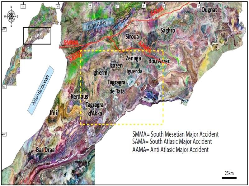
The region of Tata is part of southern Morocco, in the Anti-Atlas (Fig. 1). The latter corresponds to a mountain range south of the High Atlas which extends for about 750 km long and 250 km wide, following a SW-NE direction, from the Atlantic Ocean in the West to Algeria at East; it is limited to the North by a fracture zone called South Atlasic Major Accident (SAMA) and South and SSE by the Paleozoic Tindouf Basin. It forms the northern edge of the West African craton with an Eburnian and Pan-African basement and a Paleozoic cover deformed by the Hercynian orogeny. It corresponds to a vast asymmetrical anticlinorium of direction ENE-WSW whose heart is constituted of Precambrian grounds injected with magmatites which are outcropping at the level of several inliers (Bas-Draa, Ifni, Kerdous, Akka, Ighem, Bou Azzer, Saghro ...). These inliers belong to the northern extension of the West African craton. The Western and Eastern Anti-Atlas are separated by the Anti-Atlas major accident. The Mesozoic cover is represented by the Hamadas which remained tabular.
Géomorphosites are landforms that have acquired scientific, cultural and historical, esthetic, and/or socioeconomic value because of their perception or exploitation by humans (Panizza and Piacente, 1993; 2003; Panizza, 2001, Reynard and Panizza, 2005, Sellier 2010, Portal 2012, Bétard et al., 2017, Hobléa et al., 2018). In the present work, we will highlight some géomorphosites of the territory of the region of Tata. The latter is located in the pre-Saharan zone of southern Morocco, in the Southern Anti-Atlas (Fig.1). These géomorphosites constitute a good part of the memories of the Earth. For several years now, this geography has made the Tata region the conjunction of several landscapes of spectacular forms, known as a unique oasis region of its kind. Simplified Geomorphologic Framework From a geomorphological point of view, the present relief of the Tata region is young, resulting from the Mio-Pliocene area being elevated about 11 million years ago. The present hydrographic network was initiated at the beginning of this epoch by favoring the dissection of the relief and preparing the action of the meteorological agents of the erosion to give rise to modelings qualified of géomorphosites. These highly contrasted reliefs and their major features are mainly organized from the South and the SE to the North and the NW into five morphological units (Fig.2):
• Draa plain (Fig. 3d): it is part of the South of the Anti-Atlas; is at an average altitude of 450 m and is cut by Draa river and its tributaries. It is composed of large, stony flat surfaces called “Regs” more or less sandy where “emerge” many ridges more or less blunt, discontinuous, and whose alignment is parallel to that of Jbel Bani. These hills, called “Rich,” can culminate at 774 m;
• Jbel Bani (Fig. 3b): this is a mountain range characterized by an Appalachian relief (Canada) in a smaller model; it corresponds to a long and narrow elevation with steep sides, and ridges more or less continuous. Its altitude, exceeding 600 m, culminates at 1641 m at Foum Zguid. The Jbel Bani consists of Ordovician-dominated rocks with schists and pelites at the base, and sandstone and quartzitic rocks arranged in sheets towards the summit. It stretches for about 400 km south of the Anti-Atlas. The Jbel Bani is dug perpendicular to its direction by the tributaries of Draa river giving rise to more or less wide clue called “Foum” according to local nomenclature;
• Feijas (Fig. 3a): they are formed of large, relatively flat and rectilinear synformal basins filled with material of the dismantling of the reliefs during the Neogene and the Quaternary composed of silts, conglomerates, travertines, and quaternary lacustrine limestones which rest in angular discordance on a mainly pelitic bedrock that dates from the Cambrian and the Ordovician. In several places of these Feijas emerge parallel rectilinear ridges made of sandstone rocks called sandstones of Tabanit;
• Mountainous reliefs (Fig. 3c): it is the zone of great elevations of the ground which form varied landscapes, rare, and exceptional. The large rivers of the mountainous reliefs have generated narrow valleys and encased in the Cambrian and Infracambrien rocks which surround the Precambrian inliers of Tagragra of Akka. These reliefs can culminate at 1650 m north of Tata; they consist of more or less blunt hills, often with a rugged appearance with steep cliffs and tabular peaks forming cuestas;
• Precambrian inliers (Fig. 3e): these are older and lower ground topographically compared to those around it. These inliers form the heart of the main anticlines in the form of windows.

Fig. 1 Landsat satellite image of the Anti-Atlas showing the geographical location of the Tata region (dashed yellow frame)
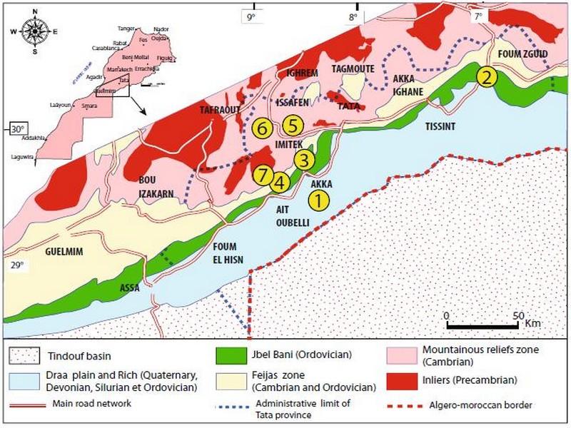
Fig. 2 Simplified geomorphological map of the Tata region (Choubert 1952). (1) Onion peels of Addana. (2) FoumZguid. (3) Akka’s badlands. (4)Hearts of Tata. (5) Karsts of Imitek. (6) Flatiron from Issafen. (7) Ppyramids of Tadakoust
Geological Setting Lithostratigraphy
The region of Tata belongs to the southern structural domain of the Anti-Atlas (Fig. 1). The latter corresponds to the distorted northern margin of the West African Craton which is organized into a mega-anticlinorium of direction ENEWSW.
It has been affected by several orogens (Eburnean, Panafricain, Hercynian, and Alpine). It presents two large lithological assemblages (Fig. 4), the oldest of which corresponds to a rigid Precambrian and Pan-African Precambrian magmatic and meta sedimentary pedestal, dated to Paléoprotérozoïque (Choubert 1947, Thomas et al. 2002), Mesoproterozoic (Ikenne et al., 2017), and Neoproterozoic (Hefferan et al. 2000, Burkhard et al. 2006). This basement is covered by an essentially sedimentary carbonate and detritic cover of the late Neoproterozoic (Adoudounian) and Paleozoic. At the outcrop, it is interrupted by several inliers where the Precambrian crystalline substratum is exposed.
The géomorphosites that are presented in this work are of Lower Cambrian and Ordovician age except for the case of the Akka Badlands dating from the Pleistocene. The Cambrian is represented by a series carbonate and detrital. From bottom to top of the Lower Cambrian, we quote:
- Talwinian (Boudda et al. 1979): baptized series lee-de-vin (Choubert 1942), maximum thickness of 600 m, consists of sandstone more or less micro conglomerate and pink to red pelites, with locally intercalated carbonates including the dolomites of Tata’s bar. It marks the beginning of a transgression and characterizes a shallow marine platform;
- Upper limestones: known at the regional scale by the Igoudine Formation (Boudda et al. 1979 and Geyer 1990) consisting of decimetric to metric of gray-white or pink dolomites with stromatolite and Archéocyatid, separated by interlocks of siliciclastic argillites or fine sandstones. Towards the top these facies shows evidence of a shallow carbonate platform in open sea conditions in which Archeocyates and Trilobites proliferate (Landing et al. 1998, Alvaro et al. 2006a, b). Its maximum thickness can reach 500 to 600 m;
- Schist-limestone series: the so-called Amousleck stage (Geyer 1990). It begins with a black limestone containing oncoids and other stromatolitic structures, surmounted by schists and silty black or purple levels interspersed with the most primitive Trilobites and Archeocyathids limestone bars.
These bars are composed of decimetric to metric beds of black oolitic limestones, sometimes gray dolomites, interspersed with prominent green gray shales, followed by limestones.
Towards the summit, the carbonate elements are dolomitic; they diminish and are replaced by deposits of silico-clastic clays;
- Schistous series: it is essentially pelitic and purplish, having a thickness which varies between 350 and 450 m, the schists are interspersed with beds of nodular scoriaceous limestones and green or purple shales with occasional fine sandstones.
Towards the top, the carbonate terms become rare and are replaced by deposits of silico-clastic clays.
The Ordovician is characterized by a mainly detrital sedimentation of platform type with some carbonate horizons. The sedimentary environment was highly subsidents, and it was the seat of epirogenic tectonics that resulted in regressions and transgressions (Destombes 1971 Destombes et al., 1985).
There are four major lithological ensembles:
- External Feijas shale with sandstone intercalation (Zini sandstone);
- First Bani: quartzitic sandstones (Lower Llandeilo-Caradoc) form powerful cliffs from 130 to 150 m and can reach 400 m. These sandstones considered regressive and would be fed from the Saharan basement;
- Schists of Ktaoua: (Upper Caradoc-Lower and Middle Ashgill) extends between the two-quartz ridges of the two Bani. This group entirely pelitic and sandstone can reach 450 m;
- Second Bani which corresponds to glacial sandstones forming a second ridge.
The Zini sandstones and sandstones of the first and second Bani form topographic ripples and escarpments which characterize in particular the Jbel Bani, whereas the schistose intercalations (Schists of Ktaoua and Tachila) are weakly exposed in the depressions and the valleys. The first Bani, is the most prominent, and its relief takes the value of lithological indicator within this semi-desert region of southern Morocco.
The Pleistocene: these are large, flat-bottomed depressions that characterize the Great Plains whose substratum is essentially schistose. At the foot of the slopes are located the main rivers fed by periodic uneven waters. The component rocks of the latter correspond to a fluvio-lacustrine filling; filling applications of these plains composed of lacustrine limestones on a chaotic conglomerate with limestone cement. The whole is covered by silts, sands, pebbles, and gravel. In places, there are detritic deposits made of fine sandstone with limestone cement. The average thickness of the set is 15 to 20 m.
Locally, these lands are rich in silts which make some oases very fertile. The cut (Thorp et al., 2002) in the silty formations has three members: a silty basal limb, a limestone inter-silt channel, and a silty summit limb. The silty formations rest abruptly on thick conglomerates of well-rounded pebbles, cemented in a massive calcrete; the cementation gains over several meters the overlying silts. The surfaces of the silty terraces are frequently covered by thin levels of rounded pebbles and pebbles, marking the return to fluviate systems carrying gravel, and angular clasts near the slopes of glacis, marking a reactivation of the slope processes. It is also important to note the importance of these plains filled with chaotic deposits that play an essential role in alluvial plain water reserves.
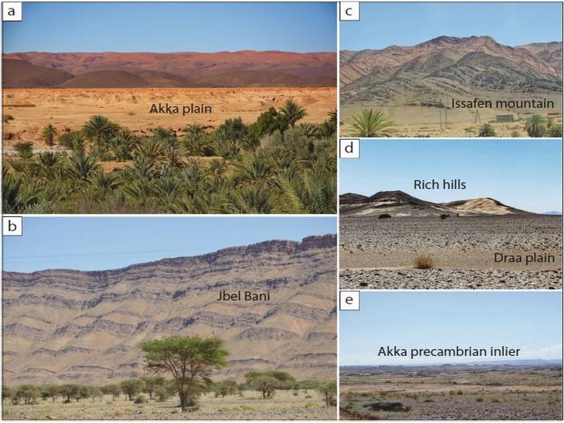
Fig. 3 Geomorphological units of the Tata region. a External Feija in Akka region. b Jbel Bani in Tat area. c Mountainous terrain in Issafen region. d Draa plain in Ait Ouabelli region. e Inlier of Tagragra of Akka
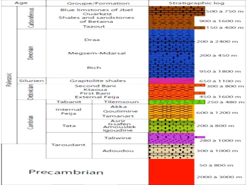
Fig. 4 Stratigraphic column of the Paleozoic Anti-Atlas (Michard et al., 2008)
Tectonics
The entire Paleozoic cover was structured following shortening of the Hercynian orogeny that generated a moderate, often polyphase, deformation style. The latter is characterized by two phases of Hercynian ductile deformations D1 and D2 in response to the shortening of the Precambrian basement brittle shrink following inverted games of old faults. This results in the formation of F1 folds of Upper Devonian EWand NW-SE grade, and Upper Carboniferous F2 folds of direction NNESSW to NE-SW(Caritg et al. 2004; Faik, 2005;Michard et al. 2011, 2008).
In addition to the ductile phase of shortening, a brittle tectonic phase follows, partially represented by the joints. They are defined as open fractures with no relative movement of the two compartments they separate and show no sign of crushing (Hodgson 1961; Babcock 1973; Engelder and Geiser 1980; Ramsay and Huber 1987; Pollard and Aydin 1988). In the Tata region, there is a very high density of joints that are organized into several directional families. The fractures of each family are generally quasi-parallel, flat, with a fairly regular spacing.
By convention, each direction of a family of joints is denoted J1, J2, Jn. It is recalled that this type of fracture is related to particular tectonic contexts, often to folds. In the case of a fold (Fig. 5) and with respect to its axis, one can distinguish longitudinal joints (J1), transverse joints (J2), and oblique joints (J3,J4, ...). The density of joints in the study area is a geological reality that would have channeled the shape of the relief in this sector where we can distinguish the superposition of six families of joints (Ouanaimi 2004) well marked especially in schist and schist-limestone series (Lower Cambrian series).
The joints are obviously areas of weakness very vulnerable to the processes of erosion; as a result, they have conditioned the directional formation of the geomorphosite relief that we will see later.
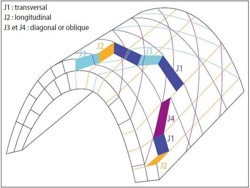
Fig. 5 Diagram showing fold-related joints (from Ramsay and Huber 1987)
Geomorphosites of Tata Region Addana Onion Peels
The Ordovician outcrops south of Tata, at the Jbel Bani but also in the form of anticlines scattered in the Draa plain. It is subdivided into four groups: group of Extern Feijas, group of the first Bani, group of Ktaoua, and group of the second Bani.
The group of the second Bani is characterized, morphologically, by a continuous ridge parallel to that of the first Bani.
This series, which is a few tens of meters thick, presents an essentially quartzitic or sandstone-quartzitic sedimentation, locally microconglomerate. Relative to the Upper Ashgill (Destombes 1971; Destombes et al. 1985), this group presents the characters of a periglacial sedimentation well known at this time on the scale of the Anti-Atlas and all of Morocco (Destombes et al. 1985; Hamoumi 1988).
The sandstone of the second Bani of the Upper Ashgill of the Addana region presents an interesting geomorphosite from the scientific and geotouristic point of view. Their GPS coordinates correspond to 29° 12′ 52′′ N, 8° 13′ 59′′ W. It shows the result of erosion under the effect of meteoric actions (Fig. 6). In the deserts, the preponderance of mechanical processes of the contrasting character of meteorological actions over physicochemical and biochemical processes is important, and is based on the fact that the climate is semi-arid or arid, which means that there is no cover plant that allows direct contact of meteoric interactions and rock.
The amplitude of the temperature variations in the arid and semi-arid regions and their speed on the rock formations causes desquamation, responsible for the degradation of the Addana sandstones in large blades. It is manifested by the detachment of lamellae or superficial scales. The process that led to the peeling of these sandstones is thermoclastic. It corresponds to a mechanical fragmentation of Ordovician sandstones under the effect of repeated and important variations of temperatures in the pre-Saharan environment. The differential responses (contraction/expansion) of the minerals to these temperature changes cause the cracking of these rocks and the appearance of desquamation scales. The blackish to grayish color of Ordovician sandstones is an important parameter controlling the magnitude of thermal variations.
The sandstones of second Bani act in a characteristic way.
The effect of the thermoclastic semi-arid Saharan climate in the region of Addana, gave this exceptional model called onion peel because of the result of its form of erosion in the form of scales of desquamation in Onion peels, and this while following the joints plans affected in this region.
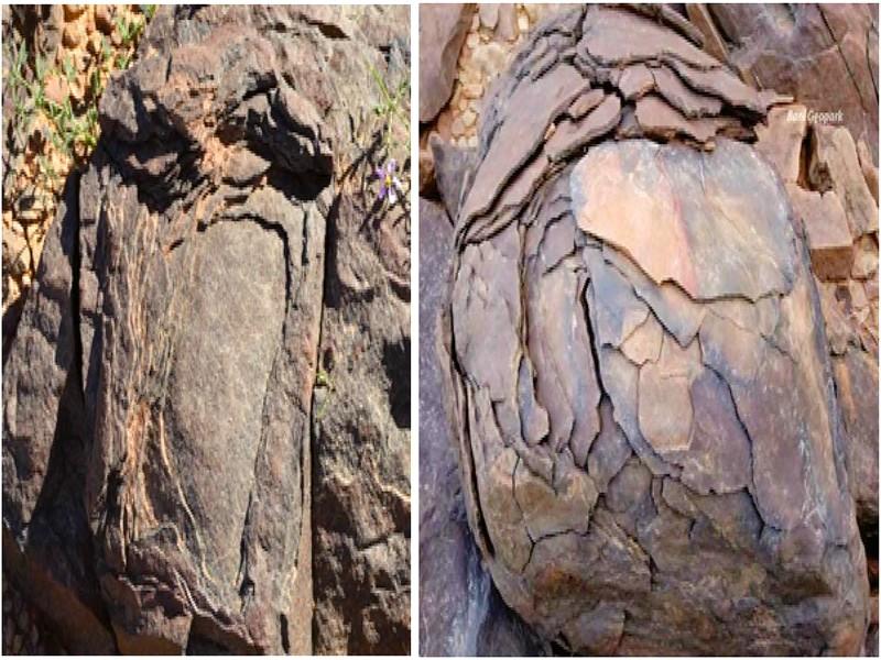
Fig. 6 Addana’s onion peels in Ordovician sandstone
Foum Zguid
The Anti-Atlas is characterized by an Appalachian chain of mountains (North American chain), but in miniature. This one corresponds to a relief of direction ENE-WSW, lengthened for hundreds of kilometers. We are talking about the mountain range of Jbel Bani. This chain culminates more than 1130 m in the West and more than 1300 m in the East; it consists of Ordovician sandstone and quartzitic and pelitic rocks (Fig. 2).
These detrital formations were deformed during the Hercynian Orogeny and underwent elevation during the Cenozoic that accompanied the formation of the current hydrographic network. The Jbel Bani is cut by several sub meridian streams which are the tributaries of Draa River.
The Ordovician mountain range of Jbel Bani, in the region of Foum Zguid, is cut by the submeridian stream of Oued Foum Zguid which is a tributary of the right bed of Oued Drâa at coordinate point 30° 5′ 46′′ N, 6° 53′ 15′′ W. This results in the formation of a “V” clue (Figs. 7 and 8). A clue is the part of a valley, usually narrowed, crossing hard layers perpendicular to their direction, if the cut of a river elongates until it intersects the hard layers, and especially until crossing an anticline, or a syncline, perpendicular to their axis.
According to the local name, the clue is named “Foum,” which means “mouth” in Arabic where the appointment of the village of Foum Zguid comes. This clue is in fact an outlet of the Foum Zguid river watershed, located north of the Jbel Bani which has drained polygenic and heterometric detritus carried by water allowing the installation of water tables over time and by consequently the establishment of important oases. This is why the agglomeration of the village of Foum Zguid settled at the level of this clue.
This clue was formed according to the model of superimposition (Fig. 9), that is to say, weak (horizontal) layers superimpose and unconformably overlap a pre-existing anticline which is made of resistant rocks. The river digs a valley in discordant weak layers. When the bottom of the valley reaches the top of the old anticline, it can no longer go to the right or to the left, blocked by the slopes it has just dug. It can only scratch the anticlinal on the spot in the continuity of its course (upstream and downstream) dug into the soft rock. The general erosion eroding much softer rocks than hard rocks constituting the anticline, it is found in relief after a certain time, relief then crossed by a clue.
Foum Zguid is a geological structure that corresponds to an eco-Géotourisme site interesting for the beauty of its esthetic aspect, its underlying socioeconomic role, its proximity to the national road network, and its geological peculiarity (parallel ridges in hard rock’s consisting of sandstones and quartzites, showing discontinuities throughout the Jbel Bani).
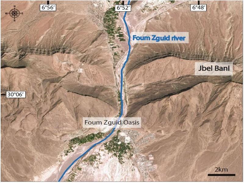
Fig. 7 Satellite image (Google Earth) of Foum Zguid’s clue Badlands of Akka Alluvium refers to the material deposited by watercourses, most often during floods, on the lower parts of their watershed.
A flow-related granulometry, an alluvium is composed of pebbles, gravel, and sand deposits often lenticular (channelized), the fine fraction corresponding to clays (less than 2 microns) and silt (it is she who dominates in the flood areas).
There are several types of alluvium: glaciofluvial alluvium, fluviomarine alluvium, and stream alluvium. These are often encountered in some areas of the watersheds of the Tata region in the form of so-called badlands (“bad land”). The silts are loose detritic deposits, clayey and silty, with very fine grain (class of lutites), continental and of fluviatile origin, lagoon, or wind (silt trays, loess).
In the territory of the Tata region, just upstream from the clues of the Ordovician Jbel Bani mountain range, there are numerous silty deposits with various structures and textures.
We quote that of the Basin of Akka River (Fig. 10) in coordinate point 29° 28′ 14′′, 8° 17′ 35′′ W. The latter offers specific morphological landscape characteristics for the needs of Géotourisme. This is an example of silt of fluviatile origin, which outcrops almost downstream of the Akka Basin which is part of the Draa watershed and specifically the Lower Draa.
The morphogenic processes responsible for shaping the badlands of the Akka river watershed are complex and generally begin with the degradation of source rocks upstream of the basin. The splitting of mother rocks into debris is the starting point of this morphogenesis, since it is in these debris, that are then mobilized by various transport processes, at a rate conditioned by the climate. These rocks in the case of the Akka river watershed are of variable lithological nature, consisting mainly of carbonate and detrital rocks. The geological map of the basin (Fig. 11a) shows that the upstream reliefs consist of mainly carbonate rocks of Adoudounian or Ediacarian age (dolomites, carbonates, clays, and marls) and Lower Cambrian (Schists, limestones, sandstone, clay). These rocks are responsible for the formation of quaternary silts, and thus for the accumulation of material from the degradation and destruction of older rocks.
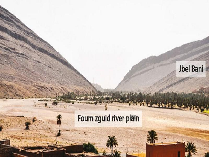
Fig. 8 Foum clue at the outcrop It is a direct consequence of runoff, rare but when it is there, most often torrential, in such a region with semi-desert climate, in this basin with a dense hydrographic network (Fig. 11b). These runoffs have a role of transport and selective redistribution of more sensitive particles, from limestone and shale formations of the late Proterozoic and Cambrian overlapping.
They are plucked from the outcrops in upstream, crossing a landscape of alluvial plain, cones, and glacis, to then passing on the slopes.
The deposition process describes the accumulation, over time, of layers of mineral matter. The fluvial environment of Akka River has deposited different kinds of clays, silts, and sand. The silts are deposited in the area of Feijas, upstream of the Ordovician clue of Akka, locally called “Foum.” The latter is crossed by the Akka river, part of the mountain log of Jbel Bani, which plays the role of the barrier, against the advance of the silt of a sense and sand in the opposite direction. These are large deposits of finely sandy loams, which are commonly dissected by the river, carrying gravel in badland topographies and large flat-topped terraces. At the edge of the Feijas, the silts overflow and bury the alluvial fans, as well as the glacis of the adjacent hill slopes. Once settled sediments have solidified, the sedimentary material becomes subject to incisive erosion.
After the accumulation of silts upstream of Akka’s clue (Fig. 12), the relief is accentuated by the digging of the rivers. All initial watercourse deposits are subject to erosion and are flushed by secondary watercourses. The latter, also dig laterally and vertically, to cut more ground in the alluvial plain of Akka river, to give this very spectacular morphology, consisting of a braided hydrographic network (Fig. 13).
Moreover, these silty formations have been cut not only by the effect of fluvial erosion (suspension and saltation of quartz grains), but also by the effect of wind erosion, since the climate of the region of Akka is desert to semi-desert. This type of erosion is translated by deflation and corrosion. The action of the wind is especially sensitive in this region where soils and rocks are not protected by a vegetal cover. The wind transports (deflation) the very fine elements; on the other hand, the coarse and very hard elements attack and erode (corrosive) the deposited silts.
Between the mountainous front and the high escarpment of Jbel Bani is observed the first vast alluvial plain. This area cut and eroded by many deep and sinuous ravines, separated by sawtooth divisions. The slope of ravine bottoms is increasing more and more in the alluvial plain vertically. The junction and the separation of the ravines give rise to numerous irregular arrows, small buttes, or mesas with flat top and create a landscape of jagged and fluted hills.
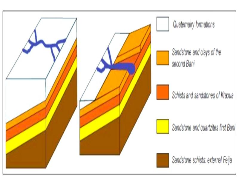
Fig. 9 Diagrams showing the stages of formation of the Ordovician Foum Zguid’s clue in Jbel Bani according to the model of the superimposition
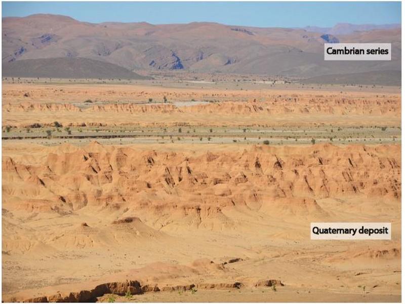
Fig. 10 Akka’s badlands
Viewed horizontally, the individual beds are traceable from one summit to another, from one mound to another and from one ridge to another, through the ravines. In aerial view (Fig. 12), the bands curve in and out of the valley like contour lines on a topographic map. The silty formations continue through the Jbel Bani Foums and form vast other sedimentary plains with mamelonous patterns drawn in clay deposits.

Fig. 11 the geological map of the Akka river watershed (fromMorocco geologicalmap 1/1 000 000 scale). B The hydrographic network and the relief of the Akka river watershed
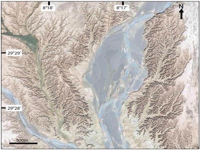
Fig. 12 Satellite image of google earth showing Akka’s badlands area upstream from Akka clue Hearts of Tata In the Tata region, some slopes of the Hercynian chain bordering the oases show depressions of metric, decametric, and hectometric extent, the outline of which underlines certain geological layers, and form a heart shape with the tip pointing downwards. These depressions, unique in their kind, present a particularly eloquent natural sculpture widespread in the region of Tata. These are true masterpieces of nature called the “hearts” of Tata (Fadli 2014). They are shaped in sedimentary rocks with flexures or slightly wrinkled with a large radius of curvature. In other words, the “hearts” of Tata are closely linked to a folded structure. The carved sides, having the same direction as that of the pleated structure, are also parallel to the line joining the axial zone of the heart-shaped depressions.
The tip of “Tata’s hearts” ends with a ravine that allows the products of the erosion of depression to be conveyed downwards.
This results in an accumulation at the feet of slopes more or less important of these products in the form of alluvial cones. The ravine crosses the totality of the depression, that is, why we perceive on the ground the shape of the heart because of the erosion of its summit.
There are many types of these hearts. They can be either isolated or grouped with a horizontal alignment that has the same direction as the folds that follow the direction of the slope. In an alignment the “hearts” of Tata are not necessarily uniform and homogeneous, their geometry and size depend on the state of progress of erosion processes and also on the homogeneity of the material made by spatial erosion. In the case presented here (Fig. 14), an outcrop showing one of Tata’s hearts with a horizontal alignment in the SW of the city of Akka at coordinate point 29° 22′ 2′′ N, 8° 19′ 19′′ W.
The morphogenesis of the hearts of Tata is conditioned by the lithological nature of the rocks that respond favorably to the structures of the Hercynian folds. Some wrinkles that originated as a result of this deformation are open with a large radius of curvature. These folds are accompanied by a dense network of joints. In the Tata region, the most common families of joints are the transverse joints, perpendicular to the fold axes and the longitudinal joints having the same direction as the fold axes. The intersection points of these two families of fractures (orthogonal joints networks) are the most vulnerable zones to the processes of weathering and erosion. At the level of the points of intersection of orthogonal joints begins the birth of crevices of generally lenticular shape and parallel to the direction of transverse joints. The pleated series often have openings at the hinge which favor the circulation of meteoric water and consequently the acceleration of the processes of erosion. Lenticular crevices can fuse with longitudinal joints at the hinge of open folds, making the points of intersection mentioned above even more vulnerable. Following regressive erosion, the first shaped layer reveals the layer below.
This process continues over time; it is accompanied by alterations and regressive erosions lateral, transverse, and vertical, allowing the crevasses to evolve into depressions. The latter will therefore widen and deepen by revealing geological layers of older and drawing in the heart of the formed heart.
Thus, we also explain why the “hearts” of Tata are located in the same alignment. Parallel to this process, the meteoric water trapped in these depressions tries to escape by gravity along the weak zones by favoring transverse joints. At this level, the rock is vulnerable to erosion and the result is the development of a ravine to drain the products of erosion. This increases the turbulence and the dynamics of the water conveyed and consequently the acceleration of the mechanical erosion at this level. This process, guided by the presence of transverse joints, could explain why “Tata’s hearts” are more or less regularly spaced when they are in a group.
The processes of erosion continue its role of destroying rocks at the intersection of orthogonal joints, digging again and again, to form depressions, which differ markedly on the slopes. The shaping results in a mechanism of regressive erosion, that is to say, an erosion that propagates from near to downstream upstream and which corresponds here to the axial zone of the heart-shaped depression. It is therefore erosion that operates in the opposite direction of the flow of water. The products of erosion accumulate at the foot of the slopes at the mouth of the ravines, forming what are known as piedmont debris cones. These are more or less spread out and overlap over time by mixing with other detrital elements from other sources of supply (carried by streams). The accumulations of the products of erosion end up giving rise to a flat surface called glacis. Most of the small palm groves of the Tata region have settled in these silt-rich glacis and have a notable water retention capacity with some porosity and a tight clay wall.
The concentration of heart-shaped géomorphosites in the Tata region results from at least five geodynamic parameters specific to this region. We cannot talk about one parameter without mentioning the others because they are closely related to each other. We cite the following:
& the lithological nature of rocks
& the Hercynian orogenic folding style;
& the high density of joints;
& the great diversity of processes of erosion and weathering And & Plio-Quaternary climatic conditions.
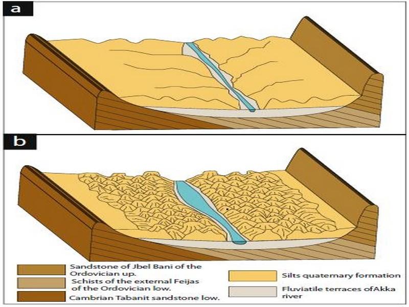
Fig. 13 Stages of morphogenesis of Akka’s badlands. a Accumulation of the fine fraction (clay and silt) in the form of silts. b Silt erosion by a braided hydrographic network giving a spectacular morphology
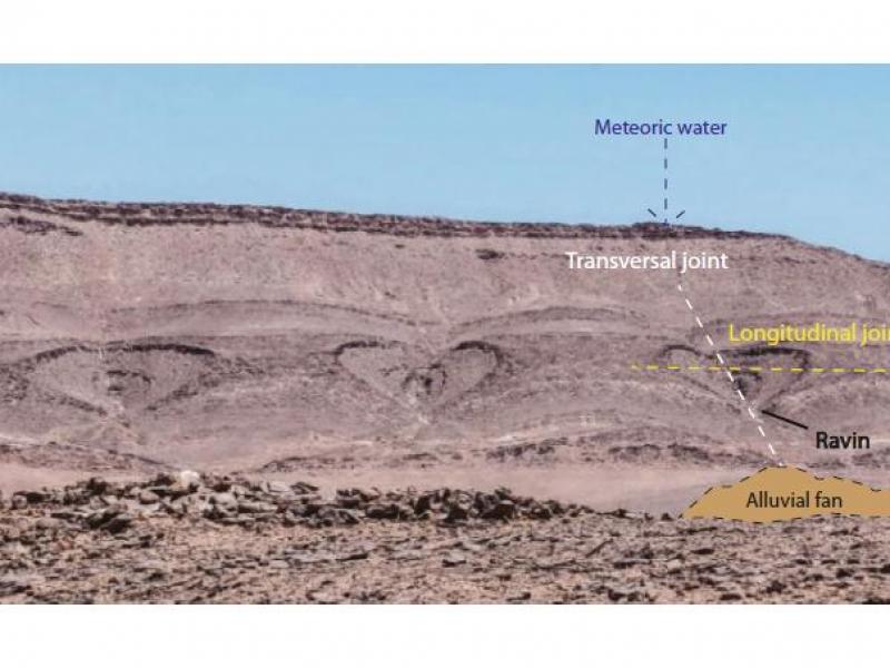
Fig. 14 Hearts of Tata at SWof the city of Akka
Karsts of Imitek The word karst (a German word: Slavic kras) refers to landscapes that develop mainly on regions with thick masses of limestone. These rocks are at the same time impervious, even when large, and liable to be dissolved by rainwater charged with carbon dioxide, and thus with carbonic acid. The dissolution of rocks allows the establishment of an extensive network of water circulation in the depths of the rock. The karst forms are divided into two families depending on whether they develop on the surface or inside limestones.
The karstic formation of Imitek (Fig. 15) is a type of relief carved by infiltration of surface water. It is located about 30 km from West of the city of Tata and a few kilometers SE of the village of Imitek at coordinate point 29° 36′ 57′′ N, 8° 15′ 40′′ W. It corresponds to the outcrop of HF and MF slabs, slightly inclined, scattered, and strongly jagged in several places forming a forest of “domes,” “pinnacles,” “peaks,” or “menhirs” UHM to metric more or less blunted and almost evenly spaced.
The karstic formation of Imitek is shaped in the carbonate levels of the schist-limestone (Choubert 1952) so-called Amusleck (Choubert 1963; Geyer 1990) Lower Cambrian stage. This series consists of an alternation of schists and limestones with a power of 150 to 300 m, and it begins with a black limestone member containing oncoids and other stromatolitic structures, surmounted by shales and black or purple silty levels where interspersed with limestone bars with the most primitive Trilobites and Archeocyathids. These bars are composed of decimetric beds with metric oolitic beige limestones outcropping and black at break; sometimes they appear in gray dolomites intercalations centimeter beds of prominent green gray shales, followed by limestones. Towards the summit, the carbonate elements are dolomitic; they are gradually replaced by deposits of silico-clastic clays.
The forms produced in these karsts are delimited by the network of dissolution channels which is guided by at least four families of joints, characteristic of the region of Tata. The observation of the latter shows that their spacing is almost regular and has very distinct directions: the longitudinal family J1 which has the same direction as the planes of stratifications, direction NS to N15; the family J2 transverse direction East-West and two families J3 and J4 oblique direction respectively N70 and N120. According to the places, one predominates over the others. These joints allow the penetration of surface waters which, when they are loaded with carbon dioxide, will start the digging process of the schist-carbonate series by dissolution. This one is very active, and the first beds of limestones will be initially cut in blocks. Subsequently, the joints widen little to form rectilinear crevices that can reach a depth of a few tens of decimeters by isolating “domes” for example. When the processes of erosion affect all families of joints, the result is the formation of another type of element which is in the form of “Menhir.” The surface of the differentiated elements present, under the effect of the erosion of many lapiaz or lapies. It is a surface bristling with grooves and channels separated by sharp blades. Added to this phenomenon is wind abrasion, which manifests itself in a semi-arid Saharan context.
Issafen Flatiron
The simple chevron style known worldwide of the erosion of the formations of a monoclinal limb, is in the form of pointed Vupwards. They appear as the intersection of straight lines spaced regularly, and forming an acute angle with the line of greater slope. The layers, in this case, retain the same radius of curvature from bottom to top of the monoclonal series.
On both sides of some main roads in the Tata region, the terrain is cut transversely by valleys. The latter, which are called “V,” topographically delimit rocks in chevrons recalling the shape of an iron whose tip is directed towards the sky. It is called this architecture, characteristic of the region, modeled type “flatiron.” In general, the observer confuses his shape by giving illusion that it is about repetitive angular folds. On the other hand, they are “false-folds” which constitute one of the traps tended to an observer wanting to make a structural reading of this type of landscape.
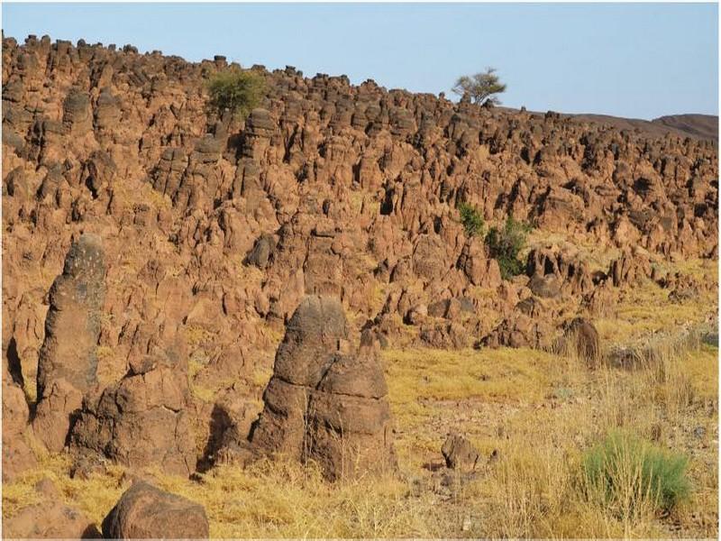
Fig. 15 Karst formation of Imitek
The Issafen’s flatiron (Figs. 16 and 17) is a very representable and pronounced example. At the outcrop, they are clearly visible since the geological layers of the limb are inclined towards the observer. They are located southwest of the city of Issafen at the coordinate point 29° 50′ 50′′ N, 8° 31′ 1′′ W.
They are carved in the Lower Cambrian series of the folded structure of the asymmetrical syncline of Issafen. They consist of an almost regular alternation of limestone (or sandstone) and pelites more or less carbonated in decimeter beds to metric.
The presence of soft pelitic levels facilitates the shaping of the whole of this series.
It is important to note that the greater the dip of the geological layers (more than 45°), the lower the radius of curvature of the chevrons. Conversely, over this dip is small plus the radius of curvature of the chevrons is important. The radius of curvature of the tip of the iron is constant from top to bottom of the Issafen chevrons slope since these monoclinal layers have a constant dip greater than 40°.
The dense network of joints existing in the region of Tata was decisive in the morphogenesis of the “Issafen’s flatiron” since they behaved in zones of weakness with respect to the processes of erosion. The geodynamic processes leading to the morphogenesis of iron-like modeling begin with erosion at the level of transverse joints (Fig. 18a). It results from parallel cuts of a monoclinal series along joints which evolve into small valleys whose tip of the V is directed downstream, according to the dipping direction of the layers which is also that of the flow of water. This morphogenesis continues with the regressive erosion that generates the individualization of the forms of “flatiron,” accompanied by the formation of alluvial cones at the foot of the slopes (Fig. 18b).
This model is easily identifiable from the sky when you conduct virtual web-maps navigation over the Anti-Atlas; it shows a characteristic zigzag structure, more or less regular depending on the location. The valleys that separate each “iron” are sub parallel and are often equidistant.
Morphogenesis of the “flatiron” type is conditioned simultaneously by the lithological nature of the rock, by the presence of joints, by the dipping of layers (greater than 40°), and by the agents of erosion and their hydrodynamics.
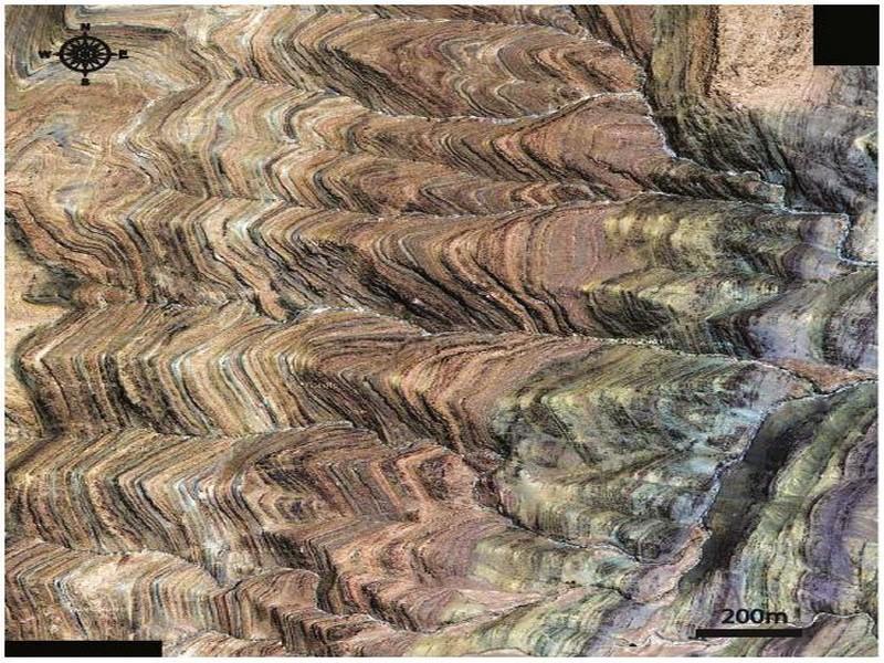
Fig. 16 Issafen’s flatirons in SWof the Issafen city
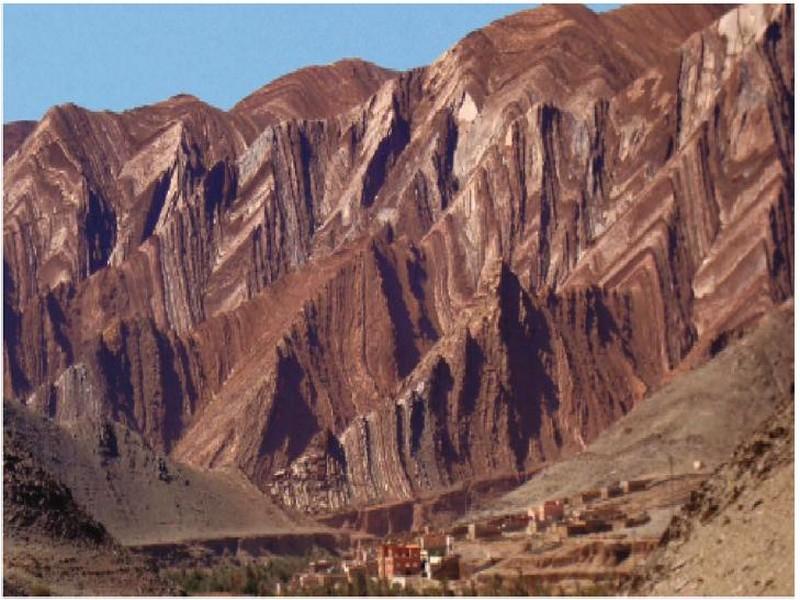
Fig. 17 Google Earth satellite image showing Issafen’s flatirons Pyramids of Tadakoust the Tata region is home to some of the most remarkable geomorphological features. It is the presence of hills of circular or oval forms more or less isolated. The most important is a rock formation called the pyramids of Tadakoust (Fig. 19). They are so called because they recall the pyramidal shape of the pyramids of Egypt. They are located about 15 km west-northwest of the rural town of Ait Oubelli, and they are organized in the form of regularly spaced pyramids at the foot of which is the village of Tadakoust which is also characterized by magnificent géomorphosites. Their GPS coordinate is 29° 19′ 35′′ N, 8° 31′ 52′′ W.
This architecture is fashioned in carbonate rocks that alternate with Lower Cambrian (about 500 million years ago) detritic beds known as the “Shale-Limestone Series.”
These lands are part of a termination of a weakly folded anticlinal map structure, direction NE-SW, with an axial dip towards the SW. The lithological nature and the succession of these rocks are represented by limestones more or less massive, often recrystallized, of buff beige color alternate with sets of limestones sandstone, silts, and pelites, with very pronounced stratification and flow in frequent platelets. Some carbonate beds are fossiliferous with particularly Archaeocyaths which correspond to the first metazoan builders of reefs.
The morphogenesis of the Tadakoust pyramids is closely related to the fracturing of the area that guided the erosion processes. The Tadakoust region is affected by two orthogonal networks of normal faults, weak discharges, and respective directions NE-SW and NW-S.
These faults are found at the level of the village of Tadakoust in the form of orthogonal joints, of the same directions, which are clearly visible both in plan and in section. These networks of joints played a determining role in the morphogenesis of the pyramids of Tadakoust.
The latter, before their formation, were partitioned by the orthogonal joints which are therefore zones of weakness very vulnerable to the processes of erosion, in particular the alteration. Over time, some partitioned areas evolve into depressions, thus differentiating well-aligned pyramids.
On one of these pyramids, whose summit is located 750 m above sea level stands an old defensive fortress.
Its position dominates the current village, the palm grove, and the surrounding territory. It is the Agadir of Tadakoust which was also a former collective attic. It can be accessed by borrowing with difficulty a winding staircase that rises in successive steps over a height of about 30 m. The enclosure that protects this building stands on the edge of the very steep cliff, which offers us an impassable fortress. This wall very solid and completely built in dry stone, extends about 100 m of length and 60 m of width with a height which varies between 1.50 and 4m.
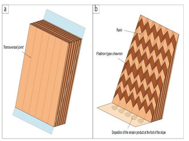
Fig. 18 Morphogenesis of chevrons of the “flatiron” type. a Monoclinal series before the processes of erosion. b Individualization of the of “flatiron” forms by regressive erosion, accompanied by alluvial cones
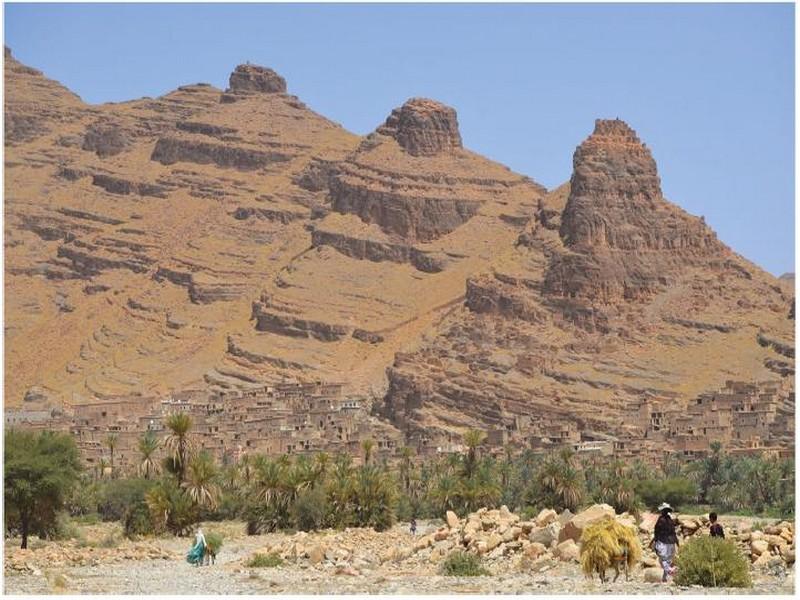
Fig. 19 Pyramids of Tadakoust
Conclusion and Perspectives The geomorphological peculiarities of the géomorphosites of the Tata region are induced and guided in time and space by several parameters related to the evolution of the internal and external geodynamics of the Anti-Atlas from the Precambrian to the Present. These are essentially lithological or structural. The great diversity of erosion and weathering processes and hostile climatic conditions during the Plio-Quaternary period of this region with a Saharan to semi-arid climate played a key role in the particular landscape architecture characteristic of this region.
In this work, we have presented some examples of these sometimes exceptional and endemic morphological forms. These are Onion peels from Addana; Foum Zguid; badlands of Akka; Tata hearts; karsts of Imitek; Issafen’s flatirons, and Tadakoust’s pyramids. All of these geomorphosites are carved in Paleozoic lands, except for the Akka badlands dating back to the Plio-Quaternary.
This work is carried out as part of the foundation in 2013 of the so-called “Géoparc Jbel Bani)” project (Berred and Fadli, 2016; Berred et al., 2019), which will be open in the Tata region and surrounding areas (Beraaouz et al., 2010). UNESCO Global Geoparks are single, unified geographical areas where sites and landscapes of international geological significance are managed with a holistic concept of protection, education, and sustainable development.
We are trying to explore and add more other géosites to those already mentioned in earlier works: Soulaimani and Ouanaimi, 2011 …
This study is one of the contributions in the realization of this project which highlights in a simplified way and accessible to all public, the natural and scientific potentialities of the region of Tata. It is intended for intellectual and professional recipients in the field of Earth Sciences to have new illustrations and effective educational uses of communication concerning the genesis of geomorphological structures in the region. It is also a didactic approach to geology very useful for secondary school teachers. It allows the tourist to make a simplified reading of the landscape with educational and cultural connotations using a mediation that is accessible to him.
This is an added value for the promotion of tourism, allowing the actors of this field to have new examples among the existing natural sites. This work should encourage public authorities and political decision-makers to become aware of the importance of this type of geological monument as a Natural Gift, by integrating it into a spatial planning policy in order to enhance it and enhance its value, to protect in a tourist perspective and by also highlighting the underlying tourist product (folklore, historical monuments, local products, and gastronomic traditions, and others ...).
References
Alvaro JJ, Clausen S, El Albani A, Chellai EH (2006a) Facies distribution of the Lower Cambrian cryptic microbial and epibenthic archaeocyathan-microbial communities, western Anti-Atlas, Morocco. Sedimentology 53:35–53
Alvaro JJ, Ezzouhairi H, Vennin E, Ribeiro ML, Clausen S, Charif A, Ait Ayad N, MoreiraME (2006b) The early Cambrian Boho volcano of the Graara massif, Morocco: Petrology, geodynamic setting and coeval sedimentation. J. Afr. Earth Sci 44:396–410
Babcock EA (1973) Regional jointing in southern Alberta. Canadian Journal of Earth Sciences 10(12):1769–1781
Beraaouz M, Masrour M, Atrops F, Bouchou L (2010) Les géosites des provinces de Ouarzazate et Zagora (Maroc): interprétation et valorisation dans le cadre du géotourisme. Geomaghreb 6:121–131
Berred S, Fadli D (2016) Géosites et Géomorphosites témoignant de l’instabilité synsédimentaire des séries carbonatées de l’Ediacarien terminal et du Cambrien inférieur (Géoparc du Jbel Bani, Sud Marocain). Notes etMémoires du service Géologique du Maroc:15
Berred S, Fadli D, Berred K (2019) Aerial interference of Hercynian foldsbvand their morphological peculiarities in the Bani Geopark of southern
Morocco. Arabian Journal of Geosciences 12(11):1–10. https:// doi.org/10.1007/s12517-019-4537-3
Bétard F, Hobléa F, Portal C (2017) Les géopatrimoines, de nouvelles ressources territoriales au service du développement local. Annales de Géographie 717:5/2017, 160 p
Boudda A, Choubert G, Faure-MuretA(1979) Essai de stratigraphie de la couverture sédimentaire de l’Anti-Atlas: Adoudounien—Cambrien inférieur. Notes Mém. Serv. géol. Maroc 271:1–96
Burkhard M, Caritg S, Helg U, Robert-Charrue C, Soulaimani A (2006) Tectonics of the Anti-Atlas of Morocco. Comptes Rendus Géosci 338:11–24
Caritg S, Burkhard M, Documun R, Helg U, Kopp L, Sue C (2004) Fold interference patterns in the Late Palæozoic Anti-Atlas belt of Morocco. Terra Nova 16(1):27–37
Choubert G (1942) Constitution et puissance de la série primaire de l’Anti-Atlas, vol 215. Comptes rendues Académie des Sciences, Paris, pp 445–447
Choubert G (1947) L’accident majeur de l’Anti-Atlas. Comptes rendues Académie des Sciences Paris 224:1172–1173
Choubert G (1952) Le volcan géorgien de la région d’Alougoum (Anti- Atlas). C. R. Acad. Sci 234:350–352
Choubert G (1963) Histoire géologique du Précambrien de I’Anti-Atlas. Notes Mémoires Service Géologique Maroc 162:l–352
Destombes J (1971) L’ordovicien au Maroc. Essai de synthèse stratigraphique. Colloque Ordovicien –Silurien, Brest 1971, vol 73. Mémoire du Bureau de Recherches Géologiques et Minières, Paris, pp 237–263
Destombes J, Hollard H, Willefert S (1985) In: Holland CH (ed) Lower Paleozoic rocks of Morocco, in Lower Palaeozoic of North-WesternandWest-Central Africa, vol 4. Trinity Coll., Dep. of Geol, Dublin,pp 91–336
Engelder T, Geiser P (1980) On the use of regional joint sets as trajectories of paleostress fields during the development of the Appalachian Plateau, New York. J Geophys Res 85:6319–6341. https://doi.org/
10.1029/JB085iB11p06319
Fadli D (2014) Les “coeurs” de Tata et leurs dérivés: géomorphosites emblématiques pour un géotourisme incontounable du Sud marocain, 1st edn. Faculté des Sciences de Rabat, RABAT, 270
Faik F (2005) Evolution stratigraphique et structurale d’un segment de la marge nord du craton ouest africain (Tata, Anti-Atlas occidental, Maroc) : du rifting fini protérozoïque à l’orogenèse hercynienne.
Thèse Doctorat d’état, Université .Ibn Zohr, Agadir, Maroc, 260 p
Source web Par: Prof. Sanae Berred, Prof. Driss Fadli, Prof. Mohammed El Wartiti, Prof. Mohammed Zahraoui, Prof. Khadija Berred, Prof. Ridouane Sadki
Les tags en relation
Dictionnaire scientifique
Plus de 123.000 mots scientifiques
Les publications
Géo parc Jbel Bani

Circuits & excursions touristiques

cartothéques


Photothéques
Publications & éditions

