
Recherchez sur le site !
Recherche avancée / SpécifiqueCatégories publications
+ Sciences De La Terre - Archéologie - Astronomie - Spéléologie - Ecologie - Pédologie - Volcanologie - L'hydrogéologie - Géomorphologie - Minéralogie - Pétrologie - Paléontologie - Géologie + Climatologie - Réchouffement climatique - Changement climatique + Plantes - Plantes Aromatiques - Plantes médicinales + Zoologie - Faunes + Botanique - Flors + Sciences humaines - Géo Eco Tourisme - L’anthropologie - L'Histoire - Démographie - Sociologie - Géographie - Patrimoine culturel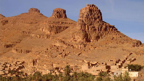
Géo éco tourisme inclusif

Géoparc et Recherche Scientifique
Le coins de l’étudiant


Blog Géoparc Jbel Bani


Aerial interference of Hercynian folds and their morphological peculiarities in the Géoparc Jbel Bani of southern Morocco (Géoparc Jbel Bani)
By Sanae Berred & Driss Fadli & Khadija Berred
Received: 12 September 2018 /Accepted: 16 May 2019
# Saudi Society for Géosciences 2019
Abstract
The Géoparc Jbel Bani of southern Morocco belongs to the chain of Anti-Atlas; it is characterized by a very heterogeneous ductile deformation, materialized by the succession of two Hercynian folding phases. The latter were controlled by Precambrian basement fractures that played into normal faults that replayed in reverse faults at the end of the Hercynian orogeny. It will be shown that this adaptation of the base to the cover propagates and amortizes laterally and vertically, giving rise to a very heterogeneous deformation. In the Tata-Akka region, the interference of these two phases of folding is spectacular in aerial view.
In several places, it has generated structural patterns, some of which are known as Begg tray,^ which show a great diversity of relief shapes after erosion processes. Other interference patterns recall the shape of mushrooms belonging to the second type according to the Ramsay classification. Of these facts, it presents a scientific interest for the researchers, esthetic for the
Géotourisme, and educational in the field of Earth sciences. In this work, we will first highlight the general characteristics of the two phases of folding in the Tata-Akka area; then, we will try, through a scientific mediation, in a tourist perspective, to understand the origin, singularity, and value of forms of relief involved in this type of deformation. It is also a question of showing the pedagogical integration concerning the close relations between the folded geological structure and the formation of relief in the potential tourist circuits of the Géoparc Jbel Bani of southern Morocco.
Keywords Southern Morocco. Anti-Atlas. Géoparc Jbel Bani. Fold interference. Géomorphosites. Scientific mediation
Editorial handling: Eugenio Fazio
* Sanae Berred
berredsanae@gmail.com
1 Faculty of Sciences Rabat, Laboratory of Geoscience, Water and Environment, Mohammed V University, Rabat, Morocco
2 Faculty of Sciences Rabat, Tourism Engineering Laboratory, Heritage and Sustainable Development of the Territories, Mohammed V University, Rabat, Morocco
Introduction
As part of the Anti-Atlas of Morocco, the region of Tata-Akka (Fig. 1) occupies the eastern part of the Western Anti-Atlas.
Located east of the Precambrian Massif of Kerdous, it is limited to the North by Ighrem inlier, to the West by Kerdous inlier and to the East to the South by Draa plain.
This area consists of a Precambrian basement, reported in the Mesoproterozoic (Ikenne 2017) and Neoproterozoic (Pan-African Orogeny), Paleoproterozoic (Eburnian Orogeny), and Proterozoic sedimentary cover that unconformable rests on the basement, attributed to the late Neoproterozoic and basal Cambrian, and finally the Paleozoic cover structured during the Hercynian orogeny, characterized by a very heterogeneous ductile deformation and materialized by the succession of two Hercynian folding phases. The latter were controlled by Precambrian basement fractures that played in normal N-S, NE-SW, and E-W faults and replayed later in reverse faults at the end of the Hercynian orogeny.
Paleozoic cover adapted to the basement propagating and amortizing laterally and vertically, giving rise to a very heterogeneous deformation in the series that it has with the birth of two families of folds F1 and F2. In the Tata-Akka region, the interference of these two phases of folding is spectacular in aerial view and gave reasons for interference in Begg tray^ as well as crescent shapes or boomerang but also mushroom, classify types 1 and 2 Ramsay and Huber 1987. This morphology present scientific interest to researchers, esthetic for Géotourisme and educational in the field of Earth Sciences.
In this work, we will first highlight the general characteristics of the two phases of folding in the region of Tata-Akka; then, we will try, through a scientific mediation, in a geotouristic perspective, to understand the origin, singularity, and value of the forms of relief involved in this type of deformation.
It is also a question of showing the pedagogical integration concerning the close relations between the folded geological structure and the formation of relief in the potential tourist circuits.
With a goal of Géotourisme development in the region of Tata, a geopark project is launched. The latter called Géoparc Jbel Bani which defines the province of Tata and the surrounding area, defined by the University Mohammed V in 2013 in collaboration with the provincial council of Tata. It is being studied more deeply in Géotourisme as well as other types of heritage, particularly cultural.
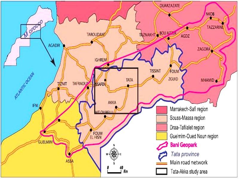
Fig. 1 Geographical location of the Tata-Akka study area Geological setting
The oldest land in the Tata-Akka region begins with Paleoproterozoic series of metamorphic and granitic nature (Fig. 2). They are affected by the Eburnian cycle, whose average age is between 2200 and 2030 Ma (Thomas et al. 2004).
Above is the Mesoproterozoic (Ikenne 2017), then in angular discordance the Neoproterozoic series, composed of metasedimentary and magmatic units. They are affected by the Pan-African orogeny, a second cycle recognized in the region with its major compressive phases. This Precambrian basement outcrops in the area studied at the inliers of Tagragra of Tata, Agouliz, Aigou, Tanmrout, Agoulmine, Tagragra of Akka, Ait Abdallah, and Amzrou.
From the late Neoproterozoic to the basal Cambrian, a major extension took place in the Anti-Atlas, then generating normal family accidents that cut the basement into blocks in the form of hemigrabens and horsts, then controlling the sedimentation of the overlying series such as the volcano-detritic formation of the Upper Ediacarian of Ouarzazate series, recognized as synrift deposits (Soulaimani et al. 2003).
A third orogenic cycle has occurred since the last Proterozoic deposits and continued for most of the Paleozoic, where the Western Anti-Atlas functioned as a passive margin by accumulating a series of thicknesses of roughly 10 km (Bertrand-Sarfati et al. 1991; Villeneuve and Cornee 1994). This orogenesis by its two compressive phases is responsible for the lifting of the basement blocks, by a tectonic inversion, occurred by two phases of heterogeneous Paleozoic deformations. The first is an early NW-SE submeridian giving rise to the formation of NE-SW subequatorial F1 folds; this compression is responsible for vertical and horizontal motions along E-W and NE-SW accidents. The second corresponds to a subequatorial major structure at NE-SW giving rise to the formation of submeridian folds F2 to NNE-SSW.
The submeridian F2 folds are superimposed on the subequatorial F1 folds, thus giving rise to interference structures generally located between the Precambrian inliers, in the Adoudounian and Cambrian terrains, illustrating varying patterns of interference.
The replay of Precambrian Basement Accidents in reverse faults or overlaps has generated ductile structures of the overlying series in the Paleozoic cover, which depreciates laterally and vertically from the base to the summit, beginning with a triangular deformation zone. They differ according to the lithological nature, or the proximity of the series with the base and major accidents.
The Cambrian Basin operated as a generally shallow platform, characterized by carbonate and detrital deposits whose detrital inputs would come from the NE (Fig. 3).
The lie-de-vin series (Taliwinian) plays a role as being the level of detachment (folds of detachment) for the overlying series, by the incompetence of its levels composed mainly by pelites. The Ordovician, which corresponds to the quartzitic formation of the Jbel Bani, is deformed by box or asymmetrical folds; there is also the presence of the folds of detachments at the level of pelitic intercalations and folds of detachment or B fault-bend-fold^ at the level of sandstone-quartzitic series. The Silurian, characterized by schists, constitutes a level of detachment and disharmony. The Devonian sandstone is deformed by open elongated folds straight or asymmetrical often have horizontal axes or weakly plunging. There is also the presence of chevron folds locally in sandstone. For what remains of the Paleozoic formations, there is difficulty of access to outcrops because of political problems, and therefore there is unfortunately no information on its ductile structures (In Faik 2005).
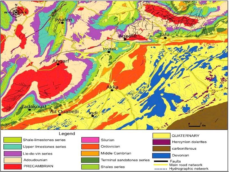
Fig. 2 Geological map of the Tata-Akka study area
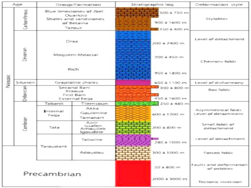
Fig. 3 Stratigraphic log of the Hercynian series of the Anti-Atlas
Structural sitting
We have made a structural map of the Tata-Akka region of ductile deformations (Fig. 4) from the satellite images to better understand the Hercynian ductile structuring and to identify the fold interference zones. The main deformation of the Paleozoic cover is materialized by folds of varying sizes, geometries and directions (Faik 2005).
Kilometric to multi-kilometric folds affecting the entire Cambrian (Lower and Middle Cambrian) coverage around the inliers. They are large synclines and can be either symmetrical (syncline of Imi-n-Tatelt, Tagmout, Fouanou) or asymmetrical (synclinal of Issafen), and less large and generally symmetrical anticlinals outcrop at the inliers (Choubert 1952).
The HF to MF folds encountered throughout the Paleozoic cover are subdivided into two axial directions: N-S to NE-SW and E-W to NW-SE. The N-S folds at NE-SW are generally isopic with straight axial planes and slightly overturned towards the east, with the presence also of box and disharmonic folds (In Faik 2005). The folds E-W to NW-SE are clearly overturned towards the South. They mainly affect the base of the cover (Lower limestones, Lie-de-vin series, and Upper limestones) and are often synclines perched at the top of the hills. We also note the presence of symmetrical folds with low axial dipping towards the North, presenting locally a disharmony at the schists of the Lie-de-vin series.
The centimetric to metric folds observed mainly in the basic carbonate series (Lower limestones, Lie-de-vin, and Upper limestones) have NS axis disharmonic folds and WNW-ESE oriented folds parallel to the basement direction, which testifies to the influence of movements of the accidents of the base on the deformation of the cover.
Two fold directions have been identified generally. These are subequatorial F1 to NE-SW folds and submeridian F2 to NNE-SSW folds. Most of the folds are structured at the level of the axial zone of the mega-anticlinorium of the Anti-Atlas in the Adoudounian formations located between the Precambrian inliers (Choubert 1963; Hassenforder 1987).
We identified four fold interference zones F1 and F2: East of the Issafen syncline; south and east of Tagragra of Tata’s inliers; south of Agouliz inlier and south of the city of Tata.
These interference zones formed in the Adoudounian, Lower Fig. 3 Stratigraphic log of the Hercynian series of the Anti-Atlas Cambrian and Devonian lands. Each interference zone will be explained and illustrated in the following sections.
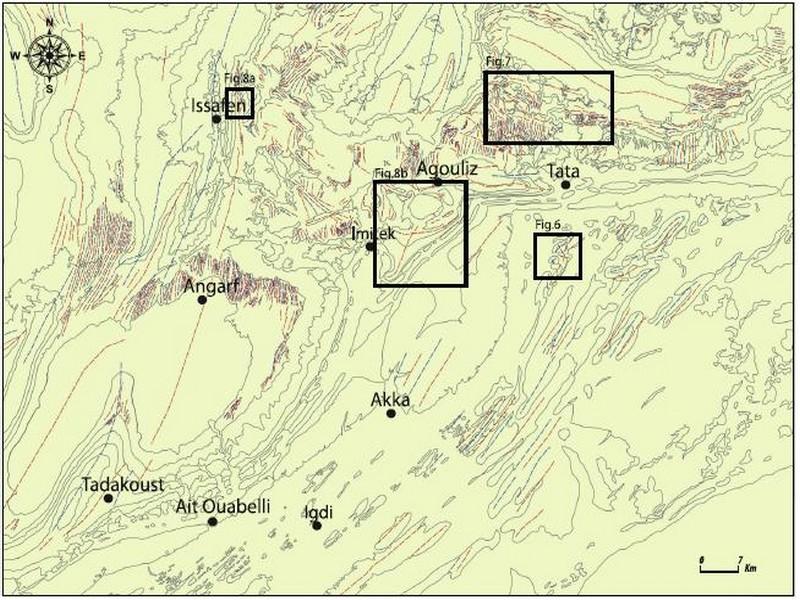
Fig. 4 Structural map of the Tata-Akka area and the location of Hercynian fold interference zones Principles and conditions of formation of superimposed folds
In an orogenic belt, there can be the succession of several phases of deformation and thus the formation of superimposed folds. Each phase of deformation contains one or more generations of folds. Finding all the deformation phases and all the generations of individual folds at the same time along the orogen is not obligatory. On the other hand, the regional distribution of the deformation is irregular and diachronous. Thus, the generations of folds and the phase of deformation become quite complex and the same for their interpretations.
We can, however, think of a single phase of deformation (Ramsay and Huber 1987; Daigneault 1991), with a variation in the time of the constraint system. It generates structures that accommodate a different direction of the deformation system that overlap with early structures.
When this is not the case, we see the deformation of several phases of folding. The folds of a later generation are superimposed on the folds of a previous generation.
Determining this time sequence, however, is not simple and requires careful spatial analysis.
Generally, there are three conditions of formation of superimposed folds: (1) that at least one of the two folds develops only widely open folds, requiring only a modest bending; (2) that the two folds are roughly coaxial; and (3) that the second folding is done by sliding-flattening: the disposition of the lithological heterogeneities is in this case more than a passive behavior (In Faik 2005). According to Gidon (1987), the third condition is most often realized.
The folds of the subsequent generation deform and reorient the folds of the previous generation.
Experimental modeling was then carried out (Odonne and Vialon 1987; Grujic 1993), showing that when there is perpendicularity of the two fold directions, we are in the presence of interference patterns in B Domes and basins^ where the initial folds are open. Then, when the two compression directions are oblique to each other, the old folds rotate, with migration of their hinges in the direction of the new fold. Ramsay (1967), Thiessen and Means (1980), and Ramsay and Huber (1987) have shown several interference patterns drawn by the strata (Fig. 5), while being dependent on the geometry and type of the first fold (Grujic 1993; Thiessen 1986).
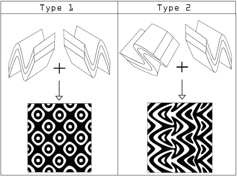
Fig. 5 Types 1 and 2 of Ramsay 1987 Earlier work
The interference structures of the F1 and F2 folds in the Anti-Atlas have been reported since the work of Choubert (1963), Jeannette (1981), and Hassenforder (1987), and since its interpretation has not been sufficiently convincing, work in this theme has not stopped to finally bring some authors to contradictory interpretations. According to Faik et al. (2001), one cannot speak of two phases of Hercynian folding, which could lead the reader to understand that there are two phases of independent deformations.
As a result, it would result from a single compression event (the main Variscan compression oriented NW) acting on a formerly dislocated basement with two sets of faults with different impacts. They defined a single phase of deformation that gave NE-SW folds, which are seen in the Ordovician and Devonian South of the Draa Plain, outside the axial zone where there is the inliers of the base. The authors argue that observed folds of trend E would have formed before NE interfering folds.
Caritg et al. (2004) interpreted this interference, which is responsible for the formation of dome and basin structures in the southern Tata region, as the result of two phases of compression: a first phase oriented NW-SE, followed by a second phase shortening NS. The folds in this case are typical of class 1 or 1–2 interference as defined by Ramsay and Huber (1987), where a first generation of open folds SW-NE and a second generation are stacked with style and length waveforms but in an EW direction.
Baidder et al. (2016) worked in the southern Tafilalt-Maider area, which appears to be a good example of inversion tectonics, with a double fold interference mechanism controlling by basement block faults and compression events Hercynian superimposed, with different compression tendencies. The result of this double mechanism corresponds to a large Cambrian anticline of crescent or boomerang, easily observed in satellite imagery.
Fold interference patterns in the Tata-Akka region
The interferences of the two directions of folds F1 and folds F2 are found in the region of Tata-Akka recorded in the Adoudounian and Cambrian series located between the Precambrian inliers, which act here as blocks of bases, moved vertically during the Hercynian compression. They also exist in the Devonian series of the Draa Plain.
The interference patterns were generated in several places, structural patterns known as Begg tray,^ which show a great diversity of relief shapes after the erosion processes. Thus, other patterns are produced reminiscent of the crescent or boomerang shape, but also mushroom pattern. All these structures were studied in Ramsay’s work where they were classified into two main members. They are present in the Tata-Akka region under different scales, in aerial view by satelliteimagery (on a multi-kilometer to kilometric and metric scale).
Type 1: dome and basin pattern
This type of interference is formed from two phases of deformation of almost orthogonal directions. The axial planes of the first folds F1 and second folds F2 show a small angle since the second deformation does not strongly deviate these axial planes from their initial planar shape. On the other hand, the first folds deviate and develop new folds plunging in remote directions or towards the axial surfaces of the first fold. This leads to the formation of strong undulations of the hinges of the first folds and the production of ridges and depressions. The hinges of the second folds combine this structure to produce peak domes and depression basins. This dome and basin pattern reminds the shape of the egg tray used for transporting eggs. Each dome is surrounded by four basins and each basin is surrounded by four domes.
On a scale from kilometer to metric, we observe in the Devonian carbonate series called B Rich^ complex interference folds (Fig. 6), with a seemingly abrupt ending of the striking NE-SW folds that stumble against Jbel Bani series, formed of a regionally dominant set of cylindrical folds. They are Tazoult basin, drawing the structural model called Begg tray,^ a little peculiar domes with axial direction NE-SW and basins with axial direction NNESSW.
This zone presents geometrically complicated structures, although it is characterized by the interference of the regional folding NNE-SSW with a fold N100 to N120: two synclines in basin, that of Tazoult and that of Ain Azemz; a median anticline, very tight, separating the two basins; and finally, a dome of elliptical section.
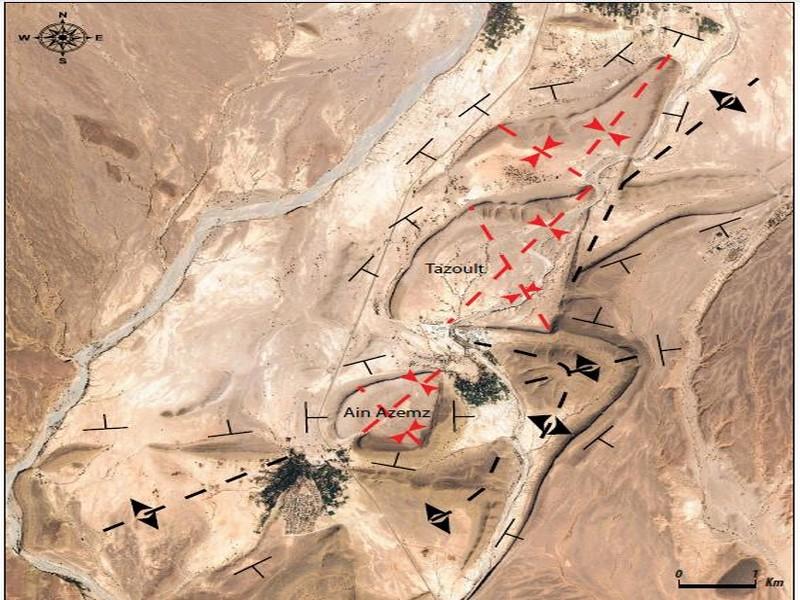
Fig. 6 Interference zone of Ramsay type 1 Hercynian folds in the Devonian series of the Tazoult region Type 2: crescent or boomerang and mushroom pattern
In this type, the angle is high between the movement of the second phase and the first axial planes of fold; thus, the first axial surfaces fold strongly and the hinges become strongly curved. The bulging of the superposition of the limbs of the first folds and the axial surfaces of the second folds has the same direction with respect to the first axial surface. The deformation of the hinges of the first fold leads to dome and basin shapes, but these structures are reversed in the same direction as that of the first folds.
In the Adoudounian and Lower Cambrian series between inliers, there are a number of this type of F1 and F2 fold interference dispersed in the region. In the south of the Tagragra de Tata inlier, there is a pattern formation especially that of crescents or boomerang of variable axial directions, depending on the position of this pattern with respect to the inlier. Figure 7 illustrates three types of this pattern with three axial directions that tend towards Tagragra of Tata inlier. Each crescent or boomerang is the result that connects two hinges of the two folds of orthogonal axial planes into an intersection zone.
East of the syncline of Issafen, another pattern was formed recalling the mushroom form, also called the head of the arrow (Fig. 8a). Thus, south of the Agouliz inlier, a mushroom pattern has occurred (Fig. 8b). At the heart of this mushroom, by going towards the village of Imitek, the great synclinal structure of Hassi-Nekhla, of circular aspect very visible in photo-aerial, is constituted by the formation of the shale-limestone series, and limited in the north by the subequatorial reverse fault of Tata; between these accidents, the Adoudounian limestones are folded by anticlinal structures.
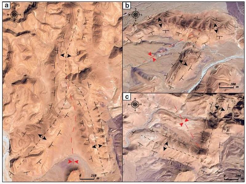
Fig. 7 a b and c Interference folds in the lower Cambrian series crescent or boomerang around the Tagragra of Tata inlier
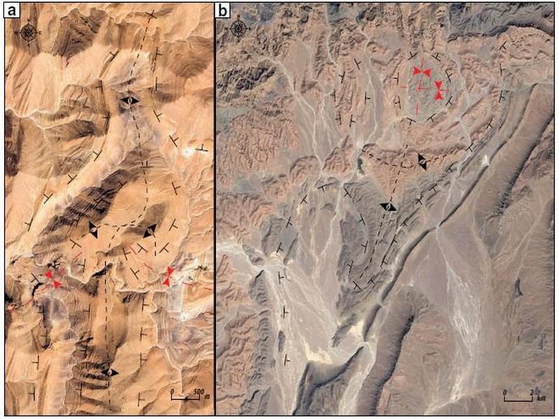
Fig. 8 Ramsay type 2 interference folds as a mushroom pattern in the lower Cambrian east of the Issafen syncline (a) and south of Agouliz’s inlier (b)
Discussion and conclusion
Géoparc Jbel Bani brings together a huge geological diversity spectacular in aerial view although in the field. In the present work, we have presented one of the geological peculiarities of this territory. These are excellent aerial-fold examples of the Tata-Akka region, a potential structural geomorphological object that illustrates the superposition of two generations of subequatorial F1 and submeridian F2, respectively. Their differently oriented axes were considered primarily housed locally associated with the inlier’s blocks. We have seen that although this object represents a dome-shaped pattern or basin, crescent or boomerang, by satellite imagery, it is able to attract more attention and curiosity from both specialists and simple tourists, to admire and contemplate their forms but so want to understand their morphogenesis created by geodynamic processes.
It also aims to show the pedagogical integration concerning the close relations between the folded geological structure and the formation of relief in the potential tourist circuits of the
Géoparc Jbel Bani of southern Morocco. To involve visitors, it is essential to provoke them by invoking research topics or by asking questions that encourage their curiosity (Rodrigues
2012) and creates the need to knowledge. In the example presented in this work, we answered a number of questions: why do we have these forms of relief? How are they trained?
Under what conditions can we have this kind of form? Why do we have them in this region? And why do they have variable directions?
Earth science education can be done in the form of a tourism activity. Organized tours or guided tours are the most complete and adapted for the visitor (Rodrigues 2012). On the other hand, some tourists prefer to visit the region in an autonomous way. For this category, the géosites must have a specific signage and in situ interpretation (signs, brochures, postcards…) on the one hand, and on the other hand in digital format with photos and videos. This experiment has already been practiced in several geoparks around the world such as Naturtejo Geopark in Portugal (André et al. 2011). Géoparc Jbel Bani aims to provide strategies and tools for interpreting the geodiversity of the region and surrounding area; to explore the geological heritage and disseminate it as much as possible with new technologies: websites, social networks; present it in scientific events; and integrate it into tourist circuits. Most geosites are generally accessible. In return, the geosites of plurikilometric sizes (aerial view) are partly inaccessible and to visit them can be accessed by various means of air transport: ballooning, helicopter, etc.
All of this involves the investment of small local projects in different sectors, giving rise to new economic opportunities, especially in rural areas where new or additional sources of income are needed (El Wartiti et al. 2009; Farsani et al. 2013).
The creation of the Lesbos Petrified Forest Geopark attracts 90,000 visitors each year and has generated 35 local jobs directly as well as new jobs created indirectly (Mc Keever et al. 2010).
The highlighting of the geoheritage of the region should encourage the public authorities to become aware of the importance of this type of heritage by integrating it into a spatial planning policy in order to enhance it and protect it from a perspective tourism to a regional socio-economic development, also highlighting the underlying tourism products (folklore, historical monuments, local products and gastronomic traditions, and others…).
References
André R, Marques R, Neto de Carvalho C, Rodrigues J, Jacinto A, Preguiça C (2011) Naturtejo Geopark signage Project: the structure of the touring offer in a large territory. In: Rangnes K (ed) Proceedings of the 10th European Geoparks Conference.
Porsgrunn, Norway, p 31 Baidder L, Michard A, Soulaimani A, Fekkak A, Eddebbi A, Rjimati EC,
Raddi Y (2016) Fold interference pattern in thick-skinned tectonics; a case study from the external Variscan belt of Eastern Anti-Atlas, Morocco. J Afr Earth Sci 119:204–225
Bertrand-Sarfati J, Moussine-Pouchkine A, Affaton P, Trompette R, Bellion Y (1991) Cover sequences of the West African Craton. In: Dallmeyer RD, Lecorche JP (eds) The West African orogens and circum Atlantic correlatives. Springer- Verlag, Berlin, pp 65–82 Caritg S, Burkhard M, Documun R, Helg U, Kopp L, Sue C (2004) Fold interference patterns in the late Palaeozoic Anti-Atlas Belt of Morocco. Terra Nova 16:27–37
Choubert G (1952) Histoire géologique du domaine de l’Anti-Atlas. In : Géologie du Maroc, 19è congrès géol. intern. Alger. Monogr. Rég.3è série Maroc. N°6 ; et. Notes et Mèm serv géol Maroc N° 100:75–194
Choubert G (1963) Histoire géologique du Précambrien de l’Anti-Atlas.
Notes Mémoires Service Géologique Maroc 162:l–352 Daigneault R (1991) Déformation et cisaillement, concepts et applications. Edition de l’université du Québec à Chicoutimi N° DV 89–16, 49
Faik F (2005) Lithostratigraphie et structures de L’Anti-Atlas centreoccidental : du rifting fini-Protérozoïque a l’orogenèse hercynienne.
Thèse de Doctoratès -sciences ; Université Ibn Zohr, Faculté des Sciences, Agadir
Faik F, Belfoul MA, BouabdelliM, Hassenforder B (2001) Les structures de la couverture Néoprotérozoïque terminal et Paléozoïque de la région de Tata (Anti-Atlas,centre-occidental, Maroc). Déformation poly-phasée, ou interactions socle/couverture pendant l’orogenèse hercynienne ? J Afr Earth Sci 32(4):765–776
Farsani N, Coelho C, Costa C (2013) Rural geotourism: a new tourism
product. Acta Geoturistica 4(2):1–10 GidonM(1987) Les structures tectoniques, BRGMManuels et Méthodes N°15. 206
Grujic D (1993) The influence of initial fold geometry on type 1 and type 2 interference patterns: an experimental approach. J Struct Geol 15: 293e307
Hassenforder B (1987) La tectonique panafricaine et varisque de l’Anti-Atlas dans le massif du Kerdous, Maroc Unpubl Thesis Doct Etat Univ Strasbourg, 220
Ikenne et al (2017) A c. 1710 Ma mafic sill emplaced into a quartzite and calcareous series from Ighrem, Anti-Atlas – Morocco: evidence that the Taghdout passive margin sedimentary group is nearly 1 Ga older than previously thought. J Afr Earth Sci 127:62–76
Jeannette D (1981) Influence des structures panafrrcaines sur les deformations hercyniennes, bordure septentrionale de la boutonniere d’lgherm, Anti-Atlas occrdental. Notes Memoires Service Geologique Maroc 32:25–3 1
McKeever P, Zouros N, Patzak M (2010) The UNESCO global network of national geoparks. In: Dowling RK ND (ed) Geotourism: the tourism of geology and landscape. Good fellow publishers, Oxford, pp 222–230
Odonne F, Vialon P (1987) Hinge migration as a mechanism of superimposed folding. J Struct Geol 9(7):835–844 Ramsay JG (1967) Interference patterns produced by the superimposition of folds of Bsimilar^ type. J Geol 60:466e481
Ramsay JG, Huber MI (1987) The techniques of modern structural geology, 2; Folds and Fractures. Academic Press, London
Rodrigues J (2012) Pedagogical geosciences tools to explain Naturtejo Geopark in both nonformal and formal environments ambientes formales e informales. Conference Paper: Publlcacicees del Serninario d Paleontología de Zaragoza, n°10. January 2012 DOI: https://doi.org/10.13140/2.1.5099.2642
Soulaimani A, Bouabdelli M, Piqué A (2003) L’extension continentale au Néoprotérozoïque supérieur-Cambrien inférieur dans l’Anti-Atlas (Maroc). Bull Soc Géol France 174:83–92
Thiessen RL (1986) Two-dimensional refold interference patterns. J Struct Geol 8(5):563–573
Thiessen RL, Means WD (1980) Classification of fold interference patterns: a reexamination. J Struct Geol 2:311e316
Thomas RJ, Fekkak A, Ennih N, Errami E, Loughlin SC, Gresse PG, Chevallier LP, Liégeois JP (2004) A new lithostratigraphic framework for the Anti-Atlas Orogen, Morocco. J Afr Earth Sci 39:217–226
Villeneuve M, Cornee JJ (1994) Structure, evolution and palaeogeography of the West African Craton and bordering belts during the Neoproterozoic. Precambrian Res 69:307–326
Wartiti ME, Malaki A, Zahraoui M, Di Gregorio F, De Waele J (2009) Geosites and touristic development of the northwestern tabular middle atlas of Morocco. In: Marini A., Talbi M. (eds) Desertification and risk analysis using high and medium resolution satellite data.
NATO Science for Peace and Security Series C: Environmental Security. Springer, Dordrecht
Source web Par: Prof. Sanae Berred, Prof. Driss Fadli ET Prof. Khadija Berred
Les tags en relation
Dictionnaire scientifique
Plus de 123.000 mots scientifiques
Les publications
Géo parc Jbel Bani

Circuits & excursions touristiques

cartothéques


Photothéques
Publications & éditions

