
Recherchez sur le site !
Recherche avancée / SpécifiqueCatégories publications
+ Sciences De La Terre - Archéologie - Astronomie - Spéléologie - Ecologie - Pédologie - Volcanologie - L'hydrogéologie - Géomorphologie - Minéralogie - Pétrologie - Paléontologie - Géologie + Climatologie - Réchouffement climatique - Changement climatique + Plantes - Plantes Aromatiques - Plantes médicinales + Zoologie - Faunes + Botanique - Flors + Sciences humaines - Géo Eco Tourisme - L’anthropologie - L'Histoire - Démographie - Sociologie - Géographie - Patrimoine culturel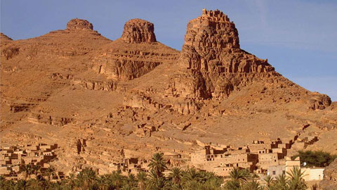
Géo éco tourisme inclusif

Géoparc et Recherche Scientifique
Le coins de l’étudiant


Blog Géoparc Jbel Bani

Tectonics of the Anti-Atlas of Morocco (Géoparc Jbel Bani)
By Martin Burkhard, Séverine Caritg, Urs Helg, Charles Robert-Charrue,
Abderrahmane Soulaimani
Institut de géologie, université de Neuchâtel, rue Émile-Argand 11, CP 2, 2007 Neuchâtel, Switzerland
BUWAL, Bundesamt für Umwelt, Wald und Landschaf, 3003 Bern, Suisse
Faculté des sciences Semlalia, université Cadi-Ayyad, av. Moulay-Abdellah, BP S20, Marrakech, Maroc
Received 4 October 2005; accepted after revision 17 November 2005
Available online 4 January 2006
Written on invitation of the Editorial Board
Abstract
The Anti-Atlas is reviewed and examined in the light of its geodynamic significance as a Palaeozoic basin and fold belt. Shortening is accommodated by polyharmonic buckle folding of the cover in a thick-skinned fashion without the development of any significant thrust/duplex systems. The Anti-Atlas is heavily inverted deep intracratonic basin, rather than a former passive margin of the Palaeo-Tethys Ocean. Inversion took place in Late Carboniferous to Early Permian times. Main shortening directions changed from NW–SE to north–south and maybe NE–SW through time, leading to the development of dome and basin patterns on scales from 100 m to 10 km. To cite this article: M. Burkhard et al., C. R. Geoscience 338 (2006).
© 2005 Académie des sciences. Published by Elsevier SAS. All rights reserved.
Résumé
Tectonique de l’Anti-Atlas marocain. L’Anti-Atlas est revu et examiné sous l’angle de sa signification géodynamique comme bassin paléozoïque et comme chaîne plissée paléozoïque. Le raccourcissement est accommodé par le plissement polyharmonique de la couverture, avec une nette implication du socle. Aucun système significatif de chevauchement ni duplex ne s’est développé.
L’Anti-Atlas est un bassin intracratonique fortement inversé plutôt qu’une partie de la marge passive de la Paléotéthys. L’inversion doit dater du Carbonifère tardif/Permien précoce. La direction du raccourcissement a changé au cours du temps depuis une direction NW–SE vers une direction nord–sud et peut-être même NE–SW, ce qui conduit à la formation de figures d’interférences de plis en dômes et bassins aux échelles allant de 100 m à 10 km. Pour citer cet article : M. Burkhard et al., C. R. Geoscience 338 (2006).
© 2005 Académie des sciences. Published by Elsevier SAS. All rights reserved.
1. The Anti-Atlas of Morocco – Introduction
The Anti-Atlas fold belt of the south-western Moroccan desert (Figs. 1 and 2) offers vast expanses of beautifully exposed bare outcrops. This is due to a recent phase of uplift and concomitant erosion that led to a rejuvenation of relief with summits of 2500 m and higher [35,47]. Geomorphologists have coined the French term relief appalachien to characterize the pattern of deeply eroded fold trains, and there is indeed a striking similarity between the geomorphic expression of the Appalachian Valley and Ridge and the Anti-Atlas.
Both chains are external parts of the larger Variscan Appalachian–Ouachita–Mauritanides orogen (Fig. 1).
The relationship between the Anti-Atlas fold belt and the internal parts of this orogen remains to be elucidated in terms of tectonic style, timing and geodynamics.
At first sight, the Anti-Atlas shares many common features with its American counterpart of the Valley and Ridge in general and with the Alleghany Basin in particular.
Both are located on the craton side of the orogen involving a thick and fairly regular layer cake of mostly shallow marine Palaeozoic sediments. Both fold provinces also have their non-folded time-equivalent intracratonic basins further inland: Michigan and Illinois on the American side, Taoudenni, Tindouf and others on the African side. On closer inspection, however, and in stark contrast to the frontal Appalachian chain, the Anti-Atlas fold belt does not easily conform to the standard anatomy of foreland fold-and-thrust belts worldwide [77]. The most striking difference is the existence of major basement domes at a very short distance behind the deformation front [76]. Similarities exist with Wind River-style basement uplifts of the frontal Rocky Mountains, but in the Anti-Atlas, the basement uplifts occur amidst a tightly folded thick Palaeozoic cover series.
The style of cover folding is quite unique too, with a dominance of upright detachment folds and a complete absence of any thrusting and duplex structures [47], with the exception of the westernmost parts of the Anti-Atlas along the Atlantic coast [8,65]. There is no thin skinned basal décollement level and the western Anti-Atlas does not conform to a foreland fold and thrust belt system in the sense of Boyer and Elliott [15].
An exhaustive review of the geology of the Anti-Atlas has been presented by Michard [64]. While many authors have interpreted the Anti-Atlas fold belt in terms of a predominance of strike-slip movements [43, 61, 74, 99], recent structural analyses depict the western Anti-Atlas folds as highly cylindrical frontal folds related with a ‘head-on’ collision in a NNW–SSE direction [20, 47, 91].
In this paper the Anti-Atlas system is revisited in light of recent data regarding the Precambrian basement, the Palaeozoic cover, structural observations within the Anti-Atlas belt as well as plate tectonic reconstructions on a global scale. Questions of particular interest concern the Palaeozoic sedimentary basin history and subsidence mechanisms as well as the evolution of this Anti-Atlas basin near the border of the West-African Craton through time.

Fig. 1. The Anti-Atlas is shown in its larger context at the End of the Palaeozoic [80]. Isopach contours for total sedimentary thickness are given in kilometres for those Palaeozoic basins which have not or only weakly been involved in inversion tectonics [102]. The same colour shades are schematically superimposed onto the Anti-Atlas fold belt in order to illustrate the estimated depth of >10 km of this basin prior to inversion.
Alleghenian basement uplifts are shown in blue (inspired by the Appalachian ‘Blue ridge’). Internal, metamorphic and in part older portions of the Applachian–Mauritanides–Moroccan Meseta are coloured in green and pink tones [44, 73].
Fig. 1. Situation de l’Anti-Atlas par rapport à la chaîne des Appalaches à la fin du Paléozoïque [80]. Les contours isopaques en kilomètres sont donnés pour les bassins sédimentaires paléozoïques qui n’ont subi que peu ou pas de déformation [102]. Le même code couleur est superposé à la chaîne plissée de l’Anti-Atlas afin d’indiquer la profondeur estimée de ce bassin avant l’inversion. Les massifs de socle alléghaniens sont indiqués en bleu
(Inspiré du Blue Ridge appalachien). Les parties internes, métamorphiques et plus anciennes, de la chaîne des Appalaches–Mauritanides–Méséta marocaine sont colorées en vert et en rose [44,73].

Fig. 2. Geologic overview map of the Anti-Atlas, compiled from the geologic map series (1:200 000) of the ‘Service géologique du Maroc’ [105–114]. NW–SE transects, used for the compilation of Fig. 4 are indicated along the southern border. A cross section through the Adrar Zouggar anticlinorium is shown in Fig. 3.
Fig. 2. Carte géologique de l’Anti-Atlas, synthétisée à partir de la série des cartes 1:200 000 du Service géologique du Maroc [105–114]. Les transects NW–SE, utilisés pour la compilation de la Fig. 4, sont indiqués le long de la bordure sud. Une coupe à travers l’anticlinorium de l’Adrar Zouggar est donnée sur la Fig. 3.
1.1. The basement
The Anti-Atlas basement is a complex assemblage of crystalline, metamorphic and sedimentary rocks. Note that we use the term basement here in the sense of the petroleum geologists [58], including all rocks older than the Gondwana Megacycle. The oldest rocks of
The West-African Craton (WAC) is granitoids, gneisses and a complex series of metamorphic rocks, attributed to the Eburnean orogeny at around 2000 Ma [2, 96, and 98]. The final assembly of most of the African continental crust takes place during the Panafrican orogeny, lasting roughly from 700 to 600 Ma [46]. Remnants of a Panafrican suture zone are present as a dismembered ophiolite series in the Bou Azzer inlier of the central Anti-Atlas [45, 55, 81, 96] – a structure recently reinterpreted as an aulacogen within the WAC [32].
Elsewhere in the Anti-Atlas, the Panafrican event left a more subtle imprint in the form of strike-slip shear zones and thrusts [43]. Post-Panafrican continental extension is well documented for the entire Anti-Atlas region [72, 89] where indications for synsedimentary tectonics are found in the clastic series of the Saghro-group (PII3) [92], the Ouarzazate group (PIII) and, progressively fading upward within lowermost Cambrian series.
The interpretation of events during the Late Neoproterozoic (600–540 Ma) is still a matter of debate, due in part, at least, to the scarcity of reliable absolute ages. The significance of the basement/cover relationships and the geodynamic context are also still open to discussion: interpretations range from syn-orogenic, Late Panafrican molasse series shed in a collision context, to post-orogenic extension and collapse with the formation of tilted blocks and halfgrabens [55, 87, and 91].
In a most recent interpretation [90], based on the type and volumes of volcanic rocks associated with the PIII Ouarzazate series, the Late Proterozoic extension event is compared with a basin and range extensional setting, with an important production of lower crustal melts.
Soulaimani and Piqué [88] even go so far as to propose the present-day Anti-Atlas boutonnières as being reactivated former metamorphic core complexes.

1.2. The cover
Prior to folding, the Palaeozoic cover series of the Anti-Atlas must have represented a fairly regular layer cake configuration. Overall thickness reaches 10 km and more in the westernmost Anti-Atlas near Tiznit and decreases to about 6 km and less in the easternmost Anti-Atlas of the Tafilalt. In terms of rheological basement/cover relationships, the sedimentary cover series is best defined as starting with the first carbonate-bearing units of the lowermost Adoudounian, following in most places concordantly upon the coarsegrained PIII conglomerates of the Ouarzazate series.
This limit makes a major colour contrast in the field and it is easily visible in satellite images. The PIII behaves as a competent basement-like unit, while the well-layered carbonates above it are increasingly detached and folded at different wavelengths from meters up to kilometres. Despite some prevailing uncertainties, the PIII/Adoudounian transition just above coincides with the Latest Proterozoic/Cambrian boundary [18,38]. There is good evidence for some extensional tectonics continuing upward into the Earliest Cambrian (Lower carbonate series of the Adoudounian) at least in the western Anti-Atlas region [3,9,10]. Lateral correlations are greatly facilitated by the presence of fossils and characteristic facies assemblages and the Anti-Atlas cover figures among the best studied Palaeozoic series worldwide [11,17,29,37,50,64,73, 101]. A schematic compilation in the form of a time chart along a strike parallel line is shown in Fig. 4.
Overall, the Anti-Atlas cover series are predominantly deposited in a shallow marine environment. Important platform carbonate build-ups are observed during the Lower Cambrian of the western Anti-Atlas [13, 38]. From Middle Cambrian to Late Silurian times, sedimentation is dominated by detrital input from the African craton, i.e. from the east and/or the south [17, 28]. Carbonate sedimentation is resumed at the end of the Silurian [50] and lasts for most of the Devonian, being combined with clastic inputs, throughout the Anti-Atlas region and beyond [100]. The Lower Carboniferous [59] is marked by a renewed increase in detrital input from the east, south and in places from the north [66, 73]. Regional-scale facies and thickness changes point toward an open ocean to the west and northwest throughout the Palaeozoic. It is therefore tempting to interpret the Anti-Atlas basin as the landward tier of the former passive margin of Gondwana, facing west and northwestward. In the preserved stratigraphic record, the shelf break, continental slope and rise of this ancient passive margin wedge are missing, however. In comparison with contemporaneous North-African Palaeozoic basins such as Tindouf, Reggane, Béchar, Ahnet, Ghadames, Illizi, Hamra, Murzuq [12], the Anti-Atlas cover series appears as just another intracratonic basin, which happened to be close enough to the continental edge to be more massively involved in Late Palaeozoic collision tectonics than its neighbours.

1.3. Cover series as a mirror of distant tectonic events?
Palaeozoic sedimentation of the Anti-Atlas region is fairly continuous throughout, and minor disconformities are most easily explained in terms of sequence stratigraphy, i.e. sea-level and/or climatic changes. Probably the most important climatic events are the Late Ordovician glaciations, recorded within the 2nd Bani micro conglomerates [39, 56, and 95] and an associated erosional discordance. The following sea-level rise is hold responsible for the deposition of the thick interval of Silurian black shales, a major source rock of the North-African realm [12,68] and a potential décollement horizon.
The famous Devonian Kellwasser–event at the Frasnian/Famennian boundary [16, 54] is probably a meteorite impact that left its imprint in the faunal assemblages.
As illustrated in Fig. 4, there is only one noteworthy interruption of the Palaeozoic sedimentary cycle in the Late Cambrian. Classically, it has been correlated with a sardic phase of orogeny [64] or with an epeirogenetic uplift [29]. The widespread (although not absolute) nature of this hiatus, common to all North-African basins from Morocco through Tunisia, Algeria to Libya [25] speaks for a general, eustatic, rather than a local, tectonic origin. Crossley and McDougall [26, (p. 160)] quote evidence for block faulting and marked angular unconformities in Algeria; similar evidence is missing in the Anti-Atlas of Morocco, where some lateral thickness changes are subtle at best, and strongly overprinted by later folding. Higher up in the stratigraphic column, subtle lateral facies changes, sedimentary wedges and minor erosional disconformities have long been interpreted as echoing distant tectonic phases such as Taconic, Acadian, Bretonne and Sudète [64], known from either the Appalachian or the European Variscides.
New palaeogeographic reconstructions (Fig. 6) of the evolution of Gondwana and the reassembly of Pangea provide a reference frame against which such statements can be tested [83,86,93].
The Late Cambrian hiatus could be interpreted as related to a new phase of rifting further north and concomitant erosion on a southern rift shoulder. At least two important Palaeozoic rifting phases have indeed been postulated to occur along the northern border of Gondwana [93]. Avalonian (and Armorican, etc.) terranes or continental fragments are supposed to originate from the northern margin of Gondwana in Cambrian times, leading to the opening of the Rheic Ocean. A second rifting event of Hunic terranes during the Lower Silurian would have led to the formation of the Palaeo-Tethys Ocean [93, (Fig. 3). In this proposal, future Avalonian and Hunic terranes represent former active subduction margins off the northwestern African craton.
Both terranes would have drifted away after two successive stages of back-arc rifting giving way to two (Rheic, Paeothethys) Palaeozoic oceans. This proposal opens new perspectives in the interpretation of events known in the various Palaeozoic terrains of Morocco.
The Anti-Atlas–Tindouf basin would not have been anywhere close to the open ocean prior to Late Silurian times. We see little evidence for rifting phases from Middle Cambrian times onward, however, and the easiest interpretation is to assume that none of those rifting events did take place anywhere close to the Anti-Atlas basin, but rather in a more external position or in a different place along the northern margin of Gondwana.
The former passive margin of Gondwana would be entirely obscured by the future Atlantic rifting and hidden below the Mesozoic onshore and offshore basins. Alternatively, the Anti-Atlas basin could be interpreted as the southeastern half of an oblique back-arc basin that evolved into a passive margin in Silurian–Devonian times, after a (right lateral?) strike-slip departure of Hunic terranes.
On a local scale, geologists have also long tried to correlate events between the Meseta, north of the present-day High Atlas chain, and the Anti-Atlas [70, 73,74]. There is no direct evidence for the existence of any kind of tectonic deformation within the Anti-Atlas at least up to Middle Carboniferous times. It is thusquite obvious that the Moroccan Meseta underwent a very different tectonic history as compared to that of the Anti-Atlas, from the Ordovician onward [69, 71].
Many parts of the complex assemblage of units in the Meseta have suffered several intense phases of deformation, metamorphism including the intrusion of granites in Silurian times and from the Lower Carboniferous onward [49]. In this respect, the Meseta is comparable to the internal Appalachian chain, with its Taconic and Acadian belts. The most important question still open in this context regards the relative position of the Moroccan Meseta block with respect to the stable African craton. In the light of the most widely accepted plate tectonic models [86], the Meseta might be regarded as a small continental fragment (or terrane) rifted off the northern margin of Gondwana during an ill-defined period in the Lower Palaeozoic, comparable to Avalonia and the more recently postulated Hunic terranes [93].
Such fragments would have been accreted again to the African craton only during the latest stages of continent–continent collision in Late Carboniferous [14, 33]. Such mobilistic proposals have been made as early as 1971 by Schenk [82], but the lack of an identified suture between the Anti-Atlas domain and the Meseta and the similarities in the Lower Palaeozoic Stratigraphic record are quoted as evidence against such a scenario [49, 51, 52, 71, 73, 75]; a recent confirmation of the Meseta block being of African affinity is provided by crustal xenoliths found in Triassic lamprophyres [31].
2. Anti-Atlas: what kind of sedimentary basin?
The Anti-Atlas Basin has been involved in Late Palaeozoic folding, uplift and erosion and it is therefore difficult to establish its true initial shape and extent to the west and to the north, where the Alpine High Atlas is a further obstacle to restorations. East and southeastward, the transition towards the neighbouring petroleum bearing Palaeozoic basins of Bechar and Reggane are somewhat obscured by a thin blanket of Upper Cretaceous sediments (Hamada), but compilations from reflection seismics reveal the gross trends in the form of isopach contour maps shown in Fig. 1 [6,102]. The Anti-Atlas actually appears to be the northern half of the Tindouf Basin. It is not clear if the two are separated from each other by some sort of swell or basement high, nor is there any known reason for the localization of the remarkably smooth trend of the Ouarkziz chain (Fig. 1), which represents the deformation front of the Anti-Atlas belt to the SSE (Figs. 2 and 3) – and the northern border of the Tindouf basin. A strikeslip boundary (of Alpine age) has been proposed to runalong Drâa lowland north of the Jbel Ouarkziz [99], but field evidence seemingly rules out any significant wrenching of any age to occur in this area [20,47,91].
To the east, the Anti-Atlas belt – or basin – turns gradually into the Ougarta chain [30,48]. Just as in the case of the Anti-Atlas belt, folding, uplift and erosion prohibit the establishment of original isopach contours for the former Ougarta Basin, but it is quite clear that this intratratonic chain is localized along a former trough of NW–SE orientation. The same structural trend is also present in neighbouring basins of Reggane and Bechar and it is generally admitted that this direction is inherited from the Panafrican orogeny [24]. Our compilation in Fig. 1 further illustrates the location of the different Palaeozoic basins with respect to the Appalachian–Variscan chain and the subsequent rifting axis of the Atlantic [80]. The question arises of what was the geodynamic setting of these different North-African basins. Is the Anti-Atlas Basin a remnant part of a passive margin of Gondwana (Fig. 6)? The total thickness of the sedimentary pile alone might be used as an argument in favour of a passive margin setting for the Anti-Atlas with the freeboard to the WNW. Other Palaeozoic basins, however, at hundreds of kilometres inboard, accumulated similar total sediment thicknesses in clearly intracratonic settings (Taoudenni > 8 km, Murzuq > 6 km). The same is true for large Palaeozoic basins on the American craton such as the Michigan (ca. 5 km) and to a lesser degree Williston, Illinois, and Hudson Bay [57]. A major argument against a passive margin interpretation is the lack of any sedimentary record for deposits from the outer shelf, talus and continental rise. Despite some general tendency to more open marine conditions westward, there are no deep water sediments preserved anywhere in the Anti-Atlas (with the exception of some debatable flysch deposits of Carboniferous age at the northern border near the High-Atlas front [66]. The determination of palaeo-water depths within the Carboniferous clastic series of the Anti-Atlas remains a matter of controversy, however. Sedimentary structures, such as graded bedding and intense convolute bedding as well as the presence of olistrostromes has been used as an indication for turbiditic flysch type sediments laid down in deep water in a compressional context [66]; we could not find any convincing flysch sequences, however, and a shallow water origin in a coastal and deltaic environment seems an equally appropriate interpretation of the sedimentary structures [41, 59].
A neutral reading of the stratigraphic record of the Anti-Atlas (Figs. 4 and 5) reveals an eventless subsidence history very comparable to contemporaneous intracratonic basins of North America [7, 53]. The to Tal accumulation curve shown in Fig. 5 illustrates the general difficulty in the interpretation of such linear on and off subsidence trends. In the case of the Anti-Atlas, more than 10 km of shallow marine sediments were accumulated over a time span of almost 200 Ma.
Even though we have not applied any decompaction or backstripping procedure, it is quite clear that this curve lacks tell-tale features of rapid tectonic rifting followed by thermal subsidence as expected in the case of a rift–drift passive margin evolution [4]. Just as in the case of the Michigan [53] and of many other intracratonic basins, the underlying mechanism of subsidence remains enigmatic [57, 85]. Explanations put forward include thermal decay, uncompensated masses, imposed load as well as the far field, flexural response to tectonic compressional forces and lithospheric buckling [85,103, 104]. The only rifting phase that left its imprint in the rock record is ill constrained in its age; the terminal Proterozoic PIII–Lower Cambrian basal conglomerate and lower limestone series are all deposited in a rifting context as confirmed by a magmatic suite of calco-alkaline to tholeiite–alkaline volcanics [90]. Even this rifting event does not clearly show up in Fig. 5 either, with less than 2 km preserved thickness of PIII series, unless we assume the Late Proterozoic rifting was short and very late. Alternatively, and more probably, the Anti-Atlas was the locus of a major broad thermal dome with limited syn-rift deposits in widely distributed small graben and half-graben systems, rather than a well defined narrow rift trough with associated shoulders. Subsequently, this broad swell (or basin and range-type collapse?) would not have led to any successful rifting in the Anti-Atlas region but to a long phase of thermal subsidence throughout the Palaeozoic.

Fig. 5. Sediment accumulation curve for southwestern Anti-Atlas (between the Goulimine and Foum el Hassan transects). Horizontal axis is time [40], vertical axis is sediment thickness as observed today, compiled from a vast body of stratigraphic literature regarding the western Anti-Atlas. No decompaction, palaeo-water-depths, eustatic corrections nor back-stripping has been applied. Principal informal formation names are given along the top of the chart, while major events of the Gondwana margin are indicated at the bottom.
Fig. 5. Courbe d’accumulation sédimentaire pour l’Anti-Atlas sud-ouest entre les transects de Goulimine et de Foum el Hassan (voir Fig. 4). L’axe horizontal donne le temps, linéaire en millions d’années, l’axe vertical donne l’épaisseur des sédiments en kilomètres. Les données ont été compilées à partir d’un grand nombre de publications concernant la stratigraphie de l’Anti-Atlas occidental. Aucune correction de décompaction, de paléo-profondeur d’eau, d’eustatisme ou de délestage n’a été appliquée. Les principaux noms de formations, informels, sont donnés en haut du graphique, tandis que les événements tectoniques majeurs sur la bordure de Gondwana sont indiqués en bas.
3. The Anti-Atlas chain – what kind of fold belt?
The western Anti-Atlas chain is dominated by highly cylindrical, upright fold trains. In contrast to the Appalachians and other foreland fold-and-thrust belts worldwide [77,78], there is no evidence for any thinskinned thrusting with the exception of the westernmost parts of the Anti-Atlas along the Atlantic coast [8,65] and some blind thrusting below the Ouarkziz ridge. In our interpretation [19, 47], the Ouarkziz ridge, a slightly curved monocline of more than 400 km length, is the surface expression of a triangle structure [97]. We postulate the existence of a blind thrust to end somewhere below the Tindouf Basin and a major NNW-vergent backthrust to re-emerge within a thick series of shales above the Devonian Rich, tightly folded and pushed under the Carboniferous Ouarkziz monocline (Fig. 3).
This mountain front of the southwestern Anti-Atlas is progressively losing its significance eastward, however [36]. East of Tata, Anti-Atlas fold trains are decreasing in number and individual folds are decreasing in amplitude, tightness and cylindricity. There is also a change in general orientation from SW–NE to east–west and the Anti-Atlas fold belt seems to merge with the Ougarta chain of SE–NW orientation [24, 30, and 48].
Some layer-parallel décollements and multiple detachments are obviously required between different structural levels, each folded with its own characteristic wavelength and amplitude, but no such décollement has ever been mapped to step up in a ramp-flat geometry across competent beds. Our recent structural analyses [20, 47] confirm previous studies [23, 64] in the sense that individual marker beds are just folded, but never thrust upon each other in a duplex style. We conclude that the Anti-Atlas folds are a natural case of truly polyharmonic buckle folding. The abundance of incompetent shales allowed the subordinate competent beds such as the Ordovician Bani quartzites and the Devonian Richs carbonates to develop their own characteristic folds. Overall map scale shortening on the order of 10 to 20% was accommodated without (cover-) thrusting [47] and the Anti-Atlas defies any straightforward interpretation in terms of a classic thin-skinned thrust system organization [15].
On the crustal scale, however, the cover shortening determined across the western Anti-Atlas fold belt, poses a serious balancing problem: where and how is this shortening accommodated within the basement?
Large structural domes, the so-called boutonnières [22] of Proterozoic basement rocks, crop out at a very short distance behind the south-eastern front of the southwestern Anti-Atlas and these basement inliers punctuate the tightly folded Palaeozoic cover. The lack of any mapped thrusts has led earlier authors to consider even these basement uplifts as just another, deeper level of crustal scale folds [22,23] dubbed plis de fonds by Argand (Fig. 5A–C) [5]. Balancing and rheology considerations make such a gentle folding interpretation improbable [67], however, and we infer that the Anti-Atlas basement uplifts must be associated with a series of major crustal scale reverse faults, supposedly in a Windriver-style well known in the foreland of the Rocky Mountains [67,76,94]. This uncommon proposal is illustrated in a section across the western tip of the Adrar Zouggar anticlinorium (Fig. 3) [27,110]. The backbone of this structure is made of Ordovician quartzites [27] and drilling in the 1960s has documented the existence of a basement core at −3.4-km depth, at least 2.5 km above the regional basement top (−5 km) as constructed between the synclinorium to the north and the Tindouf basin to the south. Gently plunging fold axis allows the projection of the Jbel Rich (Devonian carbonates) folds above the top of this anticlinorium. Southward, deformation ends below the Jbel Ouarkziz triangle structure, while northward, another major basement uplift of the Tagragra d’Akka boutonnière has led to a complete removal of all cover series. The tightly folded Bani (Ordovician) clearly projects above this basement uplift, however. The Adrar Zouggar and Tagragra d’Akka anticlinoria nicely illustrate the balancing problem associated with such basement ‘folds’. A conservative unfolding of the well-exposed Devonian and Ordovician marker beds reveals a minimum of 12 to 15% shortening ratio – this amounts to some 17 km of minimum line-length shortening (Fig. 3). In order to compensate this shortening at the basement level, we postulate the existence of a set of rather steep (40 to 60◦) faults, possibly Late Proterozoic normal faults that would have been strongly inverted. This structural style cannot be mapped in the case of the Adrar Zouggar, but it is compatible with structural observations made along the borders of more internal, deeply eroded basement inliers such as the Tagragra de Tata [21, 47]. Simple area balancing considerations allow us to estimate the depths of detachment. With an excess area of ca. 380 km2 of basement above regional, a minimum shortening estimate of 17 km requires a basal detachment in the lower crust, at ca. −32 km depth (Fig. 3). Note that presentday Moho depth is thought to be at ca. −35 km [36] at least. A more likely estimated horizontal shortening of some 25 km, taking into account layer-parallel shortening features and other bed internal strains [47], would lead to a lesser depth of detachment at mid-crustal levels of ca. −25 km (Fig. 3).
The Appalachians also used to have their basement problem in the form of the Blue Ridge (Fig. 1), a linear belt pre-Cambrian basement rocks of Grenvillian, i.e. American craton affinity [44,63,79] cropping out at some distance behind the thin-skinned frontal Valley and Ridge fold-thrust belt. While these basement uplifts have long been considered as more or less autochthonous too, crustal scale seismic reflection profiling has provided clear evidence of a truly allochthonous nature of these basement slivers, detached from the former edge of the passive margin and thrust craton-ward by up to 200 km! [44, plate 1, section C], a tectonic style anticipated by Argand [5, (Fig. 5, case E)], [63]. In comparison, our inversion interpretation of the Anti-Atlas basement domes remains very modest and autochthonous indeed and the question arises if a Blue Ridge type interpretation would not be more appropriate in the case of the Anti-Atlas? We have not found any positive arguments in favour of such an analogy, and we conclude that the similarities between the Appalachians and Anti-Atlas fold belts are not extending far below the geomorphic expression of a common Appalachian relief.
We further propose the structural style of the Anti-Atlas belt being a rather unique combination of basement uplifts in a Windriver style that happened to occur below a more than 10-km-thick series of mostly soft, shale dominated sediments. Tectonic compression of this Palaeozoic basin leads to a massive inversion of the underlying basement structures and a simultaneous polyharmonic buckle folding of the basin fill. Despite its proximity to the Appalachian–Variscan chain, the Anti-Atlas is not easily classified as a foreland fold-thrust belt to this orogen.
In many respects, it is rather to be considered as a severely inverted intracratonic basin – related to the orogen on a crustal to lithospheric scale, supposedly with a floor thrust at mid to lower crustal level. The Anti-Atlas belt has a direct connection to the Ougarta–Ahnet fold belts, but other North-African basins suffered a similar inversion event at the end of the Palaeozoic [24,42] in more isolated, clearly intra-cratonic settings. Some striking analogies in structural style and complexity also exist with the Iberian chain, an intraplate Cretaceous inversion structure in the southern foreland of the Pyrenees [84].
Interestingly, there are no intracratonic structures of Palaeozoic age known cratonward of the Alleghenian mountain front of the Appalachians. However, the very same craton reacted quite sensitively to Rocky Mountain deformations and subduction along its western border, with the formation of basement uplifts and inversion of many old graben structures hundreds of kilometres eastward, well within the North American craton [60].
4. Conclusion: plate tectonic setting through time (Cambrian to Permian)
The tectonic evolution of the Anti-Atlas basin and fold belt in relation to plate tectonics on a global scale is illustrated in Fig. 6, and summarized below:
– During the Panafrican orogeny, a series of terranes are accreted to the West African craton on its northern and probably western side. While the northeastern suture (Bou Azzer) and terranes to the northeast will remain in place, northwestern and western borders are subsequently reactivated and a series of terranes or continental fragments will be ripped off again during the Palaeozoic. The southwestern Anti-Atlas, however, at the margin of the Saharan metacraton [1] remains attached to Gondwana throughout its Palaeozoic history;
– In Late Proterozoic–Early Cambrian, the Anti-Atlas area is in extension with the formation of many widely distributed graben and halfgraben structures, filled in with coarse clastics (PIII) mostly of igneous origin. The youngest volcanism is tholeiitic–alkaline and indicates an intracontinentalsetting. The geodynamic significance of this extensional event is not entirely clear, however. It could be related to a southeast dipping, major and longlived subduction zone on the northwestern margin of Gondwana, causing a wide area of extension craton ward in a basin and range style. Alternatively, extension could be due to a (series of) hot spot(s) within Gondwana;
– From Middle Cambrian through Middle Carboniferous, the western Anti-Atlas basin is characterized by a strong and essentially linear subsidence trend, leading to the accumulation of more than 10 km of mostly fine-grained clastic sediments, shed into an epicontinental sea from the African craton. There is little evidence in this Stratigraphic record for tectonic events postulated to have taken place along the active northwestern plate margin of Gondwana [93]. The departure of Avalon, Armorica and Hunic terranes from this margin in successive events of back-arc spreading must have brought the Anti-Atlas Sea increasingly closer to the open ocean(s) (Rheic and Palaeo-Tethys).
From Silurian times onward, the Anti-Atlas Basin could thus represent the passive margin of the Palaeo-Tethys ocean, but very little if any sediments of the more distal parts of this passive margin are preserved anywhere (with the possible exception of terrains west of Guelmin [8] and near Tineghir [66]);
– In Late Carboniferous–Permian (?) compression leads to an event of strong inversion and folding.
Basement is uplifted and folded into huge antiformal culminations (boutonnières) which punctuate the southwestern Anti-Atlas fold belt. The structural relief of the basement culminations is in excess of 10 km; minimum estimates of total shortening are 15 to 25 km. The Anti-Atlas belt does not represent a classical frontal, thin-skinned foreland fold-and-thrust-belt of the Appalachian–Variscan orogen, however, but rather an intracratonic, thick-skinned basement inversion belt. Similar time-equivalent belts occur further east into the African craton (Ougarta, Ahnet), but no such structures are known on the American side of the Appalachian chain.
In conclusion, the Anti-Atlas was a fence-rider throughout, watching the action from a distance, not paying any tribute, nor suffering too much from the events going on all along the very active margins of Gondwana [49, 62].

Fig. 6. Schematic evolution of the Anti-Atlas (star) in comparison with the Appalachian chain through time on a global, plate tectonic scale.
Palaeo-tectonic reconstructions are redrawn and simplified from Stampfli and Borel [93]. Cross sections (cartoons) on the left-hand side (Appalachians) are according to Fichter [34].
Fig. 6. Évolution schématique de l’Anti-Atlas (étoile) en comparaison avec la chaîne des Appalaches à travers le Paléozoïque, à une échelle globale.
Les cartes paléo-tectoniques ont été redessinées et simplifiées à partir de Stampfli et Borel [93]. Les coupes schématiques à gauche (Appalaches) sont selon Fichter [34].
References
[1] M.G. Abdelsalam, J.-P. Liégeois, R.J. Stern, The Saharan Metacraton, J. Afr. Earth Sci. 34 (3–4) (2002) 119–136.
[2] H. Ait Malek, D. Gasquet, J.-M. Bertrand, J. Leterrier, Géochronologie U–Pb sur zircon de granitoïdes éburnéens et panafricains dans les boutonnières d’Igherm, du Kerdous et du Bas Drâa (Anti-Atlas occidental, Maroc), C. R. Acad. Sci.
Paris, Ser. IIa 327 (1998) 819–826.
[3] A. Algouti, A. Algouti, B. Chbani, M. Zaim, Sédimentation et volcanisme synsédimentaire de la série de base de l’Adoudounien infra-cambrien à travers deux exemples de l’Anti-Atlas du Maroc, J. Afr. Earth Sci. 32 (4) (2001) 541–556.
[4] P.A. Allen, J.R. Allen, Basin Analysis, Blackwell Scientific Publications, Oxford, 1990.
[5] E. Argand, La tectonique de l’Asie, in: 13th International Geological Congress, Brussels, 1924.
[6] T. Arthur, D.S. MacGregor, N.R. Cameron, Petroleum geology of Africa, new themes and developing technologies, Geological Society, London, Spec. Publ. 207 (2003).
[7] A.W. Bally, Phanerozoic basins of North America, in: A.-W. Bally, A.-R. Palmer (Eds.), the Geology of North America: An Overview, Geol. Soc. Am., 1989, pp. 397–446.
[8] M.A. Belfoul, F. Faik, B. Hassenforder, Evidence of a tangential tectonic event prior to the major folding in the Variscan belt of the western Anti-Atlas, Morocco, J. Afr. Earth Sci. 32 (4) (2002) 723–739.
[9] M. Benssaou, N. Hamoumi, The Lower-Cambrian western Anti-Atlasic graben: tectonic control of paleogeography and sequential organisation, C. R. Geoscience 335 (2003) 297305.
[10] M. Benssaou, N. Hamoumi, Les microbialites de l’Anti-Atlas occidental (Maroc) : marqueurs stratigraphiques et témoins des changements environnementaux au Cambrien inférieur, C. R. Geoscience 336 (2004) 109–116.
[11] J. Bertrand-Sarfati, A. Moussine-Pouchkine, P. Affaton, R. Trompette, Y. Bellion, Cover sequences of the West African Craton, in: R.D. Dallmeyer, J.-P. Lécorché (Eds.), the West
African Orogens and Circum Atlantic Correlatives, Springer-Verlag, Berlin, 1991, pp. 65–82.
[12] D.R.D. Boote, L.D.D. Clark, M.W. Traut, Palaeozoic petroleum system of North Africa, in: D.S. MacGregor, R.T.J. Moody, D.D. Clark Lowes (Eds.), Petroleum Geology of North Africa, Geological Society, London, 1998, pp. 7–68.
[13] A. Boudda, G. Choubert, A. Faure-Muret, Essai de stratigraphie de la couverture sédimentaire de l’Anti-Atlas : Adoudounien– Cambrien inférieur, Notes Mém. Serv. géol. Maroc 271 (1979) 96.
[14] J. Boulin, M. Bouabdelli, M. El-Houicha, Évolution paléogéographique et géodynamique de la chaîne Paléozoïque du moyen Maroc : un essai de modélisation, C. R. Acad. Sci. Paris, Ser. II 306 (1988) 1501–1506.
[15] S.E. Boyer, D. Elliott, Thrust systems, AAPG Bull. 66 (9) (1982) 1196–1230.
[16] W. Buggisch, The global Frasnian–Famennian ‘Kellwasser Event’, Geol. Rundsch. 80 (1) (1991) 49–72.
[17] W. Buggisch, R. Siegert, Paleogeography and facies of the ‘grès terminaux’; uppermost Lower Cambrian, Anti-Atlas, Morocco, in: V.H. Jacobshagen (Ed.), The Atlas System of Morocco; Studies on its Geodynamic Evolution, Springer-Verlag, Berlin–Heidelberg–New York, 1988, pp. 107–121.
Source web: Abderrahmane Soulaimani
Dictionnaire scientifique
Plus de 123.000 mots scientifiques
Les publications
Géo parc Jbel Bani

Circuits & excursions touristiques

cartothéques


Photothéques
Publications & éditions

