
Recherchez sur le site !
Recherche avancée / SpécifiqueCatégories publications
+ Sciences De La Terre - Archéologie - Astronomie - Spéléologie - Ecologie - Pédologie - Volcanologie - L'hydrogéologie - Géomorphologie - Minéralogie - Pétrologie - Paléontologie - Géologie + Climatologie - Réchouffement climatique - Changement climatique + Plantes - Plantes Aromatiques - Plantes médicinales + Zoologie - Faunes + Botanique - Flors + Sciences humaines - Géo Eco Tourisme - L’anthropologie - L'Histoire - Démographie - Sociologie - Géographie - Patrimoine culturel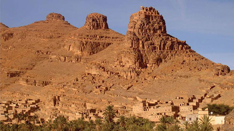
Géo éco tourisme inclusif

Géoparc et Recherche Scientifique
Le coins de l’étudiant


Blog Géoparc Jbel Bani

An Inventory of Geoheritage Sites in the Draa Valley (Morocco): a Contribution to Promotion of Geotourism and Sustainable Development
By Mohamed Beraaouz1 & John Macadam & Lhoussaine Bouchaou & Moha Ikenne & Richard Ernst & Tarik Tagma & Moussa Masrour
Abstract
This study describes the geoheritage sites in the Draa valley between Ouarzazate and M’Hamid in south-eastern Morocco. This area is remarkable for its diverse landscapes and very interesting geological, geomorphological, and archeological sites that could be used to explain the history of the earth as well as regional climate changes both to tourists and to the general public. The educational aspects of these sites are highlighted; in order to emphasize their magnificence and their scientific interest, the area includes many sites with the Ordovician Fezouata Biota. Information needs to be provided in various media, as geological and archeological booklets, guidebooks or interpretive panels at the geosites. The approach presented below can serve as a model for sustainable development of geotourism, for preservation of geological and archeological heritage, and also as a contribution toward establishing a geopark in the south-eastern provinces of Morocco.
Introduction
Located in south-eastern Morocco, the Ouarzazate and Zagora provinces belong to the Anti-Atlas Mountains and its sub-Saharan regions (Fig. 1). These provinces are characterizedµ by an arid climate, without any major industry or intensive agriculture. However, the diversity of landscapes including the Anti-Atlas area, Tabanit and Bani mountains, and desert uplands with acacia, mud brick ksours, kasbahs, and green oases make these two provinces an attractive tourist destination. The number of hotels, inns, guest houses, and camp-sites has continued to increase in recent years and reflects the growing attraction of these Saharan regions for tourists. The number of tourists is constantly increasing, mainly coming from European and Asian countries. The absence of vegetation in the two provinces allows the outstanding geology to be well exposed, and this makes the area an ideal destination for geologists from across the world either for thematic studies or for educational field trips, but the excellent exposure also means geological features and structures can be explained to nongeologists—Bgeotourists^ (Beraaouz 2011).
Research carried out by geologists during the last two decades has provided a better understanding of the geological history of the Anti-Atlas and surrounding regions (Walsh et al. 2002; Gasquet et al. 2004; Thomas et al. 2004; Hefferan et al. 2014; and references therein). In the Anti-Atlas, old Paleoproterozoic basement rocks are unconformably overlain by a Neoproterozoic (Cryogenian and Ediacaran; 1000-541million years old) cover series. The basement consists of a siliciclastic series intruded by granitoids that are dated 2050–1760 million years old. The Cryogenian to early Ediacaran rocks of the Bleida and Saghro Groups are respectively attributed to passive margin and oceanic and island-arc formation stages of the Pan-African events. The late Ediacaran series (Ouarzazate Supergroup) is mainly a syn- to post-tectonic, continental volcanic and clastic sequence associated with post-collisional granitoids (Thomas et al. 2004; Toummite et al. 2012). The transgressive series of the Taroudant Group forms the transition to the Paleozoic series. To the south, the Bani and Tabanit jbels form two parallel low mountains composed of quartzites and sandstones. They are cut by grooves (or ravines) called foums. The jbels are separated by feijas, quaternary plains underlain by shales which form a valley bounded by palm-trees along the Draa wadi. In addition to this rich geological heritage, the region contains various geomorphological forms and important areas of archeological and cultural heritage. Unfortunately, this cultural and scientific richness is not sufficiently showcased, as yet, by professionals. Tourism may be the best way to promote this heritage, but both the development of the region for current generations and the preservation of its rich heritage for future generations need to be considered. Reynard (2004) defines geotourism as a set of practices, infrastructure, and products to promote the earth sciences by tourism. It is a type of tourism through which tourists can acquire information and a clear understanding of geological and geomorphological processes in the area concerned (Malaki 2006; Komoo and Kadderi 1997). The term geotourism has also been defined as tourism where the tourist is interested in both the natural and cultural aspects of the planet and is mindful to minimize their own personal impact. In this case, the Bgeo^ of geotourism refers to the whole planet rather than merely the planet’s geology: this definition has been closely associated with National Geographic magazine, and also has been adopted, particularly in the Arouca Declaration (European Geoparks Network 2011), by many geoparks globally as more relevant to the interest they wish to engender in all aspects of their area.

Fig. 1 Map of proposed geosite locations Geotourism, in the restricted sense, will diversify what is offered to tourists and increase the attractiveness of these two provinces, but it is probable that most visitors will be interested in more than the geology.
The development of geotourism products requires a good working relationship between local elected officials, scientists (including geographers and geologists), tourism stakeholders, and professional interpreters (who may, or may not, also be geologists) (Beraaouz 2011). The basic principles of modern interpretation were first set out by Freeman Tilden, working in the USA’s National Park Service (Tilden 1957). In 2015, the IUCN Geoheritage Group stressed that interpretation is not merely the transmission of information, and that communication of geoheritage needs to be in the language of civil society (pers. comm. Roger Crofts, ProGEO Conference 2015, Reykjavik, Iceland), rather than in the special language (Bjargon^) of geoscientists (see also European Geoparks Network 2011 and UNESCO 2016). In the years since Tilden’s seminal work, accepted professional best practice in interpretation has been developed by authors such as Mike Gross, Sam Ham, and John Veverka (Gross et al. 2006; Ham 2013; Veverka 2015) and much Binterpretation^ for geoheritage can be seen to be inappropriate for the supposed target audience of non-geologists. Humor and cartoons have rarely been used in communicating for geoheritage, although there are exceptions (Macadam and Lacković 2010), and while geological books with cartoons for children are often about dinosaurs (and too often with little intended or achieved scientific credibility), some authors have worked on communicating more challenging topics with integrity, e.g., karst (Lacković 2008) and the geology of a whole UNESCO Geopark (Oki Islands Global Geopark Promotion Committee 2014). To achieve scientific integrity of interpretation, with or without cartoons and humor, scientists will need to provide the information in their specialisms for education trails, interpretive panels, booklets, and guidebooks.
This contribution will allow interpreters (who may also be science-trained), elected officials, and tourism stakeholders to develop tours in the region of Ouarzazate and Zagora cities that include visits to geosites and thereby help promote geosciences and public awareness of the importance of the preservation of these sites. Promotion of these geosites will also cause visitors to think more broadly about changes to climate and landscape on our planet. According to Strasser et al. (1995) and De Wever et al. (2006), geosites are portions of the geosphere delimited in space and with a particular geological, geomorphological, or geo-ecological significance. They are important witnesses of Earth history and collectively give an overview of landscape and climate evolution. Panizza and Piacente (2003) defined a geosite as all geological objects having scientific, historical cultural, esthetic, or socio-economic value. Geosites have also been defined in the context of the ProGEO/IUGS Global Geosites Project as of special importance for science (Ischchenko et al. 1998; Ishchenko and Gerasimenko 1999), but on the other hand, some authors are using the term geosite for any geological outcrop (i.e., Bgeological site^ = Bgeosite^): in this paper, we use Bgeosite^ in the sense of the first two definitions though several of the geosites, particularly those with Fezouata Biota, clearly are candidates for Global Geosite status, as evidenced by the success of the RALI (Rise of Ancient Life) Conference in Marrakech in 2015 which attracted participants from over 20 countries.
The term Bgeopark^ likewise has a range of definitions and has been used to refer to a space as small as an outcrop up to a large geographical area whose management can contribute to sustainable development. Since November 2015, UNESCO has had a formal designation of UNESCO Global Geopark, along with the already well-known designations of World Heritage Site and Biosphere Reserve. UNESCO Global Geoparks Bare single, unified geographical areas where sites and landscapes of international geological significance are managed with a holistic concept of protection, education and sustainable development^ (UNESCO 2016) UNESCO welcomes the inclusion of an area’s natural and cultural heritage in a geopark. Several countries (e.g., China and Germany) have National Geoparks from which a few have become UNESCO Global Geoparks. Many countries (e.g., Japan, Ireland, and Italy) also have national geopark committees which work to identify and develop new geoparks, helping them to function as a Baspiring geopark^ before formal application to UNESCO. But the desire to become a geopark—and the application dossier—has to come from the local community (UNESCO 2016). Even if an area does not become a geopark, the process of auditing of sites (as begun informally in this paper), and planning management and popularization should result in a useful plan for further progress (Macadam 2003; Macadam et al. 2006). In this paper, we use the word Bgeopark^ in the sense of a large geographical area which could develop sustainably through the Baspiring geopark^ stage to then apply to UNESCO i.e., we use the term Bgeopark^ in the same way that UNESCO does.
The provinces of Ouarzazate and Zagora are very rich in exceptional geological and geomorphological sites (geosites) that could be of major interest to tourists and should be included in the tours of travel companies.
The main purposes of this paper are the following:
& to provide an inventory of the main geological and geomorphological geosites in Ouarzazate and Zagora provinces;
& to demonstrate the importance of these exceptional sites for geotourism and to indicate other natural and cultural heritage;
& to briefly explain how these geological, geomorphological, and cultural sites could be promoted to curious visitors to increase their appreciation of the importance of both the cultural and scientific heritage.
Geosites along the Draa Valley is the longest valley in Morocco. It is irrigated by the El Mansour Eddahbi reservoir, which is located a few kilometers from Ouarzazate city and stores water from Ouarzazate and Dades wadis. From the dam, water in Draa wadi travels for nearly 200 kmbetween the towns of Agdz and M’Hamid, in the Anti-Atlas mountains, irrigating a succession of palm oases, fields, and impressive old adobe ksours.
Beyond M’Hamid, Draa wadi is lost in the sand hills of the former Iriki Lake. Along Jbel Bani, the Draa valley is rich in exceptional landscapes and has diverse geological, geomorphological, archeological, and historical sites (Fig. 1).
Stromatolite Geosite of Amane-n’Tourhart the stromatolites of Amane-n’Tourhart outcrop on both sides of the national road P31 connecting Ouarzazate to Zagora cities (Fig. 1). The site is located about 25 km south-east of Ouarzazate at N 30° 47′ 33.0″ and W 06° 43′ 19.7″.
These stromatolite limestones were reported first by Raguinin 1948 (in Choubert and Faure-Muret 1970). They form an outcrop which has proved to be the most spectacular Conophyton site in the Anti-Atlas (Choubert et al. 1952a, 1952b) with an exposure extending over about 0.04km2 (4 ha) and a thickness of 10–20 m.
Stromatolite limestone units are interbedded with andesite, rhyolite, tuff, and conglomerate of Jbel Tinghouy in the east, and andesite, tuff, and sandstone of Jbel Tissouktai in the west.
The sequence belongs to the Ouarzazate Supergroup of the upper Neoproterozoic (Fig. 2a); the three separate limestones Bbenches^ with stromatolites are clearly shown on the lithological log (Fig. 2b) for the Amane-n’Tourhart site.
Stromatolite domes outcrop in limestone deposited in a shallow sedimentary basin, most likely in a lacustrine environment.
They take the form of a lamellar structure that developed from the accumulation of carbonates or sand grains by felting of cyanobacteria. Stromatolite colonies are grouped into sub-circular or sometimes elliptical domes which are 5–60 cm in diameter and up to 1 m in height (Fig. 3a), with well preserved lamellar structure (Fig. 3b). The domes are outlined in shiny black patina and have regularly spaced fractures filled with red ochre. The importance of the site is both in its wonderful visual appearance and for its scientific importance. This site can be related to the role of stromatolites in early life on Earth.
The Formation of Stromatolites Stromatolites are interpreted as organo-sedimentary structures resulting from lithified microbial mats where cyanobacteria are the main contributors; most Proterozoic stromatolites probably accreted by microbial trapping and/or binding (Knoll 2008). Because of morphological similarity, most described Precambrian microfossils have been attributed to cyanobacterial activities (Golubic 1991; Golubic et al. 2000; Knoll 2008).
In the Amane-n’Tourhart geosite, the cyanobacteria have developed as follows: initially, some precipitation of calcareous concretions occurred at irregularities (bumps) in the muddy sediment, caused by a cyanobacteria species (this forms the lower limestone Bbench^). Subsequently, the intense growth of this cyanobacteria species, or invasions by other species, leads to growth of encrusting forms and lamellar tubes because of their biological activity during the day and inactivity during the night. Indeed, after sunset, the cyanobacteria bend over, and suspended sediment, particularly fine-grained sands and silts, settle on these cyanobacteria forming crusts, which then alternate to produce laminations. Regular growth builds both small and large domes. Lake shores receive mud that can disrupt the development of crusts and so cyanobacteria typically flourish in the middle of lakes where waters are sufficiently non-turbid. The role of stromatolites in the appearance of life on earth is very important: cyanobacteria display significant morphological and metabolic versatility (Stal 1991), two attributes that confer on them a great adaptive capacity that positions them as key precursors of early ecosystems.
Whether cyanobacteria were also present in the Archean (>2500 million years ago) is still subject to discussion, but their geobiological impact on Earth history has been crucial.
At some point in the Precambrian, oxygen released by cyanobacterial activity changed from being poisonous to becoming vital and thus changed forever the course of geobiological evolution on Earth (Chacón et al. 2011).
Unlike any other biological group, cyanobacteria triggered major evolutionary events that shaped the biosphere that we see today: cyanobacteria were the first organisms to employ oxygenic photosynthesis, being responsible for the transition of the Earth’s atmosphere from anoxic to oxic (Ehrlich 1981).
The interpretation and promotion of this stromatolite geosite are important for two main reasons: first, because it can be easily integrated into sustainable geotourism development, since it is located near the road between Ouarzazate and Zagora; and second, because the history of the primitive micro-organisms tells an important story about the history of life on Earth.
Promotion of Stromatolite Geosite of Amane-n’Tourhart this site has exceptional exposures of stromatolites in 3-D, as well as such features as ripple-marks. In some views (e.g., Fig.3a), the morphology of these Precambrian stromatolites can be seen to be similar to modern day stromatolites in Shark Bay, Western Australia (which are well-known to viewers of popular science TV programs). It is proposed that possibly two interactive panels be used to develop understanding of the life and death of stromatolites and their role in the geological record.

Fig. 2 a generalized stratigraphic column for the Anti- Atlas Pan-African orogen. PII and PIII are the classic Stratigraphic symbols used on Anti-Atlas geological maps. Modified from Gasquet et al. (2008). B Lithological log for the Amanen’Tourhart Geosite Ordovician Trilobites of Zagora Area In the Zagora area (Fig. 4), the lowest levels of the Ordovician consist of 1500 m of interbedded pelitic and ferruginous sediments of the Outer Feijas Group (Tremadocian to early Darriwilian Stages) (Destombes 2004; Lefebvre et al. 2015).
These form plains called feijas and are overlained by the micaceousvfine-grained sandstones which form 600 m cliffs at Bani Jbel. The sandstones are assigned to the First Bani Group (Early Darriwilian to middle Sandbian) and border the Draa wadi for more than 100 km. The shales of the Ktaoua Group (middle Sandbian and Katian) underlie the depression with the palm oases in the Tagounite area. The Hirnantian Stage is represented by the periglacial sandstones of the Second Bani Group. This series corresponds to the last Ordovician sedimentary cycle (Destombes 2004; Lefebvre et al. 2015; Martin et al. 2015).
Ordovician fossil sites are numerous in the Zagora area (Fig. 1). Below, we mention some verywell-known fossil sites in the Draa Valley.
Exceptional Biota of Lower Ordovician Since 1999/2000, a dozen sites of exceptional preservation have been discovered in the Ordovician of the Moroccan Anti-Atlas (Van Roy 2006; Lefebvre et al. 2016). Half of these sites were discovered in Lower Ordovician units (approximately 478 million years old) in the region of Zagora (central Anti-Atlas); others are located in Upper Ordovician units to the west of Tafilalt and around Erfoud in eastern Anti-Atlas (Van Roy 2006; Lefebvre et al. 2010).
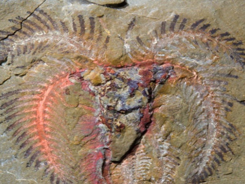
Indeed, the Upper Fezouata Formation (Lower Ordovician) in the Zagora area has revealed an exceptionally preserved biota, not only preserving more than just the hard shells of marine animals but also offering critical insights into the history of life. Such biotas are relatively common in rocks of Cambrian age, but our knowledge of life during the period that follows, the Ordovician, is almost entirely based on the evidence of shells alone (Van Roy et al. 2010). This situation has improved dramatically with the discovery of the Fezouata Biota in south-eastern Morocco, the first early Ordovician exceptionally well-preserved fossil assemblage from a normal, open marine setting. These Ordovician animals show considerable diversity and contain a large number of forms typical of older Cambrian Burgess Shale-type deposits as well as more modern-looking creatures.
The sites have yielded a benthic fauna that was extraordinarily rich and diverse, living on a muddy seabed, before being suddenly buried by an influx of sediment. The soft parts of the bodies have been preserved in the form of pyrite (iron sulfide); the alteration to iron oxide has given to the fossils a beautiful yellow, orange, or brown color (Fig. 5a, b).
These discoveries in Morocco indicate that the characteristics of the Cambrian fauna continued to have a considerable impact on the biodiversity and ecology of marine communities more than 20 million years later, into the Ordovician. In addition, the presence of a number of advanced animals, like horseshoe crabs, in the Fezouata Biota indicates that these groups had radiated into more diverse species much earlier than was previously thought, before the beginning of the Ordovician. Some indication of the richness of the fauna is shown by the black-and-white reconstruction (Fig. 6) of a dead anomalocaridid lying in an eocrinoid meadow (Lefebvre et al. 2016). The artist, pseudonymously known as Madmeg, was guided by 16 scientists for scientific integrity.
The authors provide a key and a comment that the assemblage of scavengers may seem unrealistically diverse but Bsome sites in the Fezouata Shale have yielded multiple specimens from a couple of dozen different taxa from an excavation area less than the size of an average billboard^. Over 160 genera, half of them soft-bodied, have been reported (Van Roy ET al.2015).

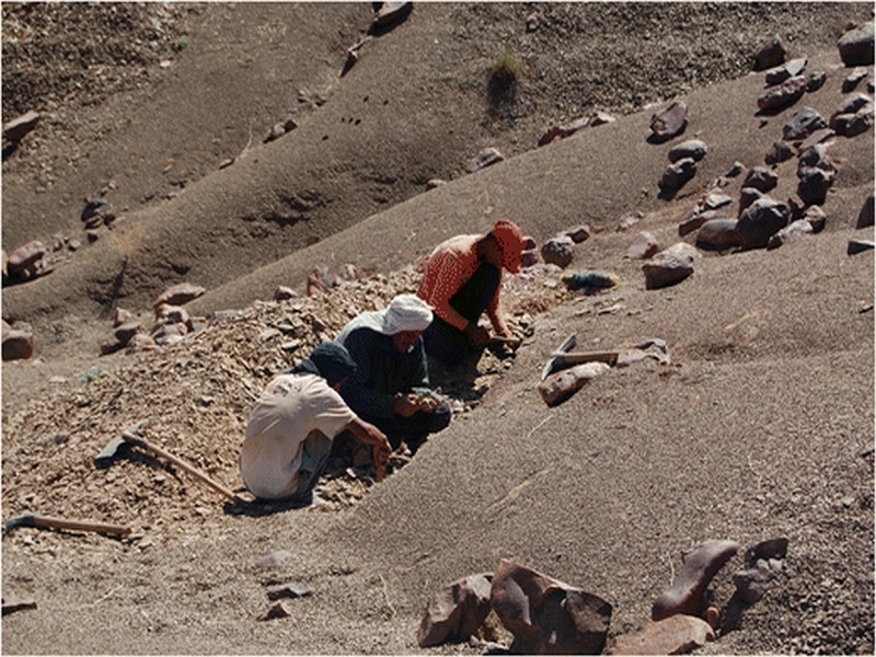
Fig. 3 Outcrop of stromatolite cupolas (fossil cyanobacteria about a half a meter in diameter). a View of site. b Close-up view Promotion and Protection of This Geosite The Zagora geosite includes a fauna characterized by its very small size (millimeter to centimeter scale, Fig. 5b) which makes it very vulnerable and easily destroyed. Another risk threatening this heritage is that all these sites contain other fossils, such as trilobites and echinoderms, have a monetary value to fossil dealers. Unfortunately, this leads to the destruction of the tiny and exceptional biota (which is of no interest for merchants) during extraction of the larger fossils (Fig. 7).
Two protective measures must be taken immediately: & the closing of the richest zone in this biota and the prohibition of all human activity that threatens the destruction of the site (particularly the extraction of fossils), and the continuous presence of a guard, as is being done by the Ministry of Culture for the Ait Wazik rock art site in the Tazzarine area, & Improving public awareness of the importance and major scientific interest of the exceptional fauna of these sites.
The Upper and Lower Fezouata Formations These formations (Tremadocian-Floian) located between Jebel Bou Zeroual and the base of Jebel Tibasksoutine to the south-east are mainly composed of pelitic and fine sandstone units totalling 550–600 m (Destombes 2004). These contain some well-known species of trilobites such as Neseuretus sp.
(Vidal 1996) and Asaphellus fezouataensis (Vidal 1996, 1998) (Fig. 8a, b). Examples of partial soft-body preservation of Fig. 3 Outcrop of stromatolite cupolas (fossil cyanobacteria about a half a meter in diameter). a View of site. b Close-up view Fig. 4 Simplified geological map of the Zagora area (modified from„ Destombes 2004; area originally interpreted by Destombes extended using satellite images by second author) trilobites have also been reported (Gutiérrez-Marco et al. 2017).

Fig. 5 a Horseshoe crab (about 5.5 cm in length) in the Yale Peabody Museum of Natural History, specimen number YPM 227586. Collected from the Lower Fezouata Formation at a site between Bou Zorgan and Bou Glf, within the Araneograptus murrayi biozone, latest Tremadocian, Lower Ordovician. b Cheloniellid arthropod (about 9.5 mm in length) in the National Museums of Scotland—The Royal Museum, specimen number NMS.G.2004.2.1.
Collected from the Upper Fezouata Formation, at Bou Chrebeb, Baltograptus jacksoni biozone, middle Floian, Lower Ordovician (images by Peter Van Roy) The Giant Trilobites of Ouled Slimane in the Ouled Slimane locality (Zagora province), the Tremadocian series provides some specimens of trilobites which are exceptional in both size and quality:
Platypeltoides magrebiensis more than 20 cm in length (Rábano 1990), Asaphellus stubbsi more than 30 cm in length (Fortey 2009), and Dikelokephalina brenchleyi about 30 cm in length (Corbacho and Vela 2010; Fortey 2010) (Fig. 9a, b). Promotion of the Fossiliferous Heritage in Zagora Region Without any significant industrial or agricultural activity in the Zagora region, tourism is the main sector for sustainable economic development and an important factor in stabilizing the rural population and limiting rural exodus. On the other hand, the absence of regulatory oversight on activities related to this sector and the excessive commercialization of fossil extraction has led to significant losses for scientific research. The exploitation of fossils in Zagora province and, in general, in the south-eastern region of Morocco is a potential source of income for many families both for fossil sellers and fossil extractors.
However, fossil extraction leads to depletion or even total loss of this geological heritage. Hence, the promotion of this fossil heritage through geotourism is needed and can be done through: & Integration of fossil sites into guided tours and inclusion on tourist maps; & Training of guides among the local population on the palaeontological aspects of the area, and the importance of such sites for tracing the geological history of the Earth; & Construction of museums in the area, where the visitors can find all the fossils of the region (trilobites and crinoids) and which will employ local people; & Training of fossil traders on molding techniques, which will allow tourists and lovers of fossils to purchase items identical to the original fossils (as happens in Araripe UNESCO Global Geopark in Brazil, and other places);
& Making interpretive panels at each fossil extraction site, with colorful reconstructions of the fauna and the palaeoenvironment, as well as images of some of the actual fossils found and their importance to science, and need to conserve them in situ; & Banning fossil extraction without authorization; & Setting up information panels at extraction sites, with an explanation of the laws prohibiting the extraction of these fossils given in several languages, and clear icons (similar to road and hazard signs) showing that collection is banned; & Increasing public awareness on the importance of this palaeontological heritage; & Enacting legal protection for designated geological sites in Morocco. A first draft of a law has been presented by the Directorate of Geology, in the relevant government department (the Ministry of Energy and Mines) at a meeting at Beni Mellal in April 2007 in M’Goun candidate Geopark, men in section 4 of the Dossier de Candidature…(Region de Tadla-Azilal et al. 2013). The representative of the Ministry who spoke at the international RALI (Rise of Ancient Life) conference in Marrakech in October 2015 made no mention of the progress of such a law—only talking about Bdiscussions^— but he did surprise the international audience by informing them of the law dating from 1994 banning export of minerals and fossils from Morocco. Minerals and fossils from Morocco are very freely on sale across Europe. Avaluable synthesis of geoheritage protection across Europe was published in 2012 (Wimbledon and Smith-Meyer (eds.) 2012).

Fig. 6 Reconstruction of a Fezouata Shale sea-floor with the corpse of a large anomalocaridid lying in an eocrinoid meadow and being scavenged by a diverse fauna

Fig. 7 Uncontrolled extraction of fossils and site destruction as a leading cause of specimen loss

Fig. 8 Examples of trilobites found in shale of Upper Fezouata Formation. a Neseuretus (about 10 cm in length). b Asaphellus sp. (more than 30 cm in length)

Fig. 9 Giant trilobite specimens from the locality of Ouled Slimane (Zagora). A Platypeltoides magrebiensis (more than 20 cm in length), Asaphellus stubbsi, and Dikelokephalina brenchleyi (about 30 cm in length). B Dikelokephalina brenchleyi Quaternary Sites Erg and Reg Geomorphosites The Ergs The word erg, also called sand sea, is a term derived from Arabic, which means in the Sahara, massive dunes, and which symbolizes the desert for most people. This desert landscape is formed by sand that is moved by wind across the rocky plains and plateaus (hamadas). Single sand dunes form kilometer size ergs after juxtaposing, combining, and merging (Fig. 10a).
The main ergs located between Zagora city and M’Hamid town are (Fig. 1) the following:
& the moving dunes of Tinfou which are located 7 km from Tamgrout and 26 km south-east of Zagora city, at N 30° 13′ 50.67″ andW5° 36′ 24.72″. Nomad tents are set up for tourists who are offered mint tea. The tents are located just a few minutes’ walk, on foot or by camel, from the dunes.
& Lihoudi erg around Tagounite corresponds to a set of dunes in which travel companies offer bivouac for the night, at N 29° 53′ 45.33″ and W 5°41′ 47.11″.
& Chgaga erg located to the west of M’Hamid town is a wide field of large dunes. It is reachable only by track with a driver-guide, at N 29° 49′ 35.60″ and W 6° 16′ 16.04″.
With the diversity of dune types in the area, geotourists will be able to be shown shield (or dome) dunes (stationary pyramidal dunes, in the form of a nomad’s tent) and barkhan dunes
(crescent-shaped and highly mobile) as well as a third type with a convex portion facing the wind (gently sloping with compact sand) and a concave portion downwind (steeply pitched with soft sand). Visitors will often be able to see the wind moving sand grains to make ripple-marks, only some centimeters to tens of centimeters high and similar in form to water ripples.
The Regs
The word reg is a term derived from Arabic which means the flat expanse of pebbles or rock debris, with mixed gravel, sand, and clay. Regs occupy a much larger area than the ergs (Fig. 10b). They cover three quarters of feijas between Bani and Tabanit mountains. The regs with acacia are numerous between Ouarzazate city and M’Hamid town. The most representative are those of Tinzouline and Tamgroutat, respectively, at N 30° 34′ 37.2″, W 06° 08′ 56.4″ and N 30° 15′ 34.2″, W 05° 41′ 3.6″ (Fig. 10b).
Given the scarcity of water and vegetation in this Saharan area, erosion depends mainly on two processes: wind erosion and thermoclasty. Wind erosion attacks outcrops removing fine-sized particles by deflation and abrasion.
Deflation occurs when the wind is strong enough to lift and transport loose material, lifting it from the ground and often carrying it for great distances. The wind picks up and removes loose particles from the earth’s surface, and thus contributes to erosion.

Fig. 10 a Moving dunes in the Chgaga erg. b Acacia reg of Tinzouline (note the black desert Patina on rocks)
The loose particles that are blown away by the wind serve as tools of destruction, abrading (wearing away) surfaces which they contact. The effect of abrasion is related to wind strength. Weathering by thermoclasty results from temperature variations that can reach 50 °C. This can cause, over the long term, cracks which gradually enlarge and eventually break the rock.
The resulting rocky plain is called a Breg^. Many of the rock surfaces in a reg have a dark surface patina of ferromanganese minerals. This Bdesert varnish^ is caused by migration of solutions carrying these elements to the surface where the water evaporates.
Archeological Sites Rock art (art rupestre) represents a valuable record of the history of humanity. These artistic expressions reflect human existence and activities and are a unique and precious heritage, both for their scientific importance and also for their artistic values. The masterpieces of rock art reflect the creativity of the first human artists.
In the Draa area, all the rock art has been engraved.
The main sites of rock carvings in the study area are Foum Chenna, Assif Ouigane, Cheaba Lbâida, Tibasksoutine, and Jorf Elkhil, of which the most important is Foum Chenna because of the number of carvings.
These sites are identified by the rock art site icon on Fig. 1 but are not individually named. Despite the importance and diversity of these engravings, few studies have been carried out in this area.
On the basis of the groups of animal species shown on the rock art, four periods are recognized:
– The oldest one is the hunter-pastoral period which is characterized by wild animals (elephants, rhinoceroses, giraffes, and ostriches), symbols (circles and spirals of varying size and shape, drawings, and sinuous lines), and various anthropomorphic representations (hunters with or without weapons, and bows, spears, and arrows) (Fig. 11a).
– The second is the bovidian period which is recognizable by the predominance of representations of cattle (cows, buffaloes, and oxen). This bovidian group is dated to the second millennium BC (Du Puigaudeau and Senones 1964). It was distinguished on the basis of representations of giant buffalo or Blarge hartebeest^ (Fig. 11b).
– The horse and Libyan-Berber period: two types of images have been linked to the same period (Du Puigaudeau and Senones 1964) because of the combination of libycoberber (Tifinagh) alphabet and horses in the same rock art. Engravings of horses are very rare, and this period cannot be older than 750 years BC (Searight 1993).
During this time in North Africa, humans first rode horses and were armed with halberds, daggers, or shields (Fig. 11c). [Note that B Amazigh^ is used nowadays in preference to B Berber^ but B Berber^ is often found in the literature.
The word B Berber^ is etymologically related to the word B barbarian. ^]
– The dromedary period: this last period is characterized by engravings of camel. A climate change proceeded this period, leading to an extended dry climate in the North African regions, accompanied by a change of the animal fauna toward those more adapted to the new climatic conditions. Camels were brought into Egypt by the Persians around 500 years BC, spreading across North Africa in the last centuries BC, and then became widespread, at the latest, by the early fourth century AD (UNESCO 1983) (Fig. 11d).
Promotion of the Quaternary Interpretive panels and guidebooks need to be produced to explain the effects of climate change during the Quaternary and the process of formation of regs and ergs. As regards the interpretation of climatic variations, research on changes to pre-Saharan and Saharan natural environments attest to dramatic climate change in the last 50,000 years ago in these regions. The climatic variations have left many geomorphological and geological effects: dry palaeolakes filled with clay and carbonate sediments (e.g., Iriki), stepped terraces on the banks of the Draa wadi and its tributaries, travertine deposits at waterfalls (Tizgui), regs and ergs. Also, the drastic changes that affected human societies and animals occupying the environment are illustrated by the rock engravings.
The liveliness of the early engravings—of antelope, lions, elephants, rhinoceros, and human populations—imply the artists had seen these animals where they were living in the Draa Valley. At that time, North Africa was characterized by numerous large and small lakes and abundant savannah (McIntosh and McIntosh 1983) (de Menocal et al. 2000), and the now hyper-arid Sahara desert was a verdant landscape (COHMAP Members 1988; Jolly et al. 1998; Sarnthein 1978). There have been many studies of the climate of North Africa and Sahara, going back to Rognon (1976) and before. Researchers have used different proxies (including lake sediments, lake levels, stable isotopes, foraminifera, diatoms, and plant material), and the studies have covered small and larger areas (Tierney et al. 2008; Damnati 2000; Meyer et al. 2011; Tabel et al. 2016; Cheddadi et al. 2016; Ivory and Russell 2016), but no research has focused on the Draa Valley.
Since active research is a requirement for a geopark, it would seem ideal for a study to analyze and synthesize evidence from dry Lake Iriki (with clay and carbonate sediments), travertine deposits at waterfalls (e.g., Tizgui), and stepped terraces on the banks of the Draa Wadi, and its tributaries, regs and ergs. It would be good if any museum or visitor center which is set up incorporated information about the on-going research, its methods, and the results, with the material being interactive with visitors being invited to B be a geologist^.

Fig. 11 a Engravings of wild animals. b Engravings of bovids (cattle). c Engraved horses and Libyan-Berber inscriptions. D Engraved dromedaries plus a man with shield on a horse
Conclusion
Based on the inventory presented above, which describes and maps the outstanding geological, geomorphological, and archeological sites in the provinces of Ouarzazate and Zagora, it would be expected that many of them could be promoted, with appropriate management, to tourists.
However, remaining sites, particularly those that are vulnerable, should be protected and not publicized in order to preserve them for future generations.
The interpretation of geosites is a very important tool for the management of geological heritage as a part of a policy for the sustainable development of tourism. The explanation of the geological, geomorphological, and archeological significance of these geosites will help visitors to understand and appreciate their significance to our heritage and the importance of their protection for future generations.
The geological heritage of the Ouarzazate-Zagora region is currently poorly known by tourists who visit this area. It is therefore necessary to stimulate interest and attract the attention of curious visitors to this heritage. Information should emphasize the magnificence and scientific interest of these geosites. Information must be presented as explanatory guidebooks, digital multimedia, geolocated guides, and interpretive Fig. 11 a Engravings of wild animals. b Engravings of bovids (cattle). C Engraved horses and Libyan-Berber inscriptions. D Engraved dromedaries plus a man with shield on a horse Geoheritage Author's personal copy panels along geological and geomorphological educational trails.
The most vulnerable paleontological geosites and archeological sites, those which are exposed to threats that could cause their destruction, are not presented in this paper to protect them from the risk of looting and trampling.
The recognition, inventorying, study, and systematic classifications of geosites will & Enhance scientific knowledge of the regional geological heritage;
& allow development of programs and innovative tourism projects through creation of a network of thematic tours related to geological heritage and geodiversity, providing added value to traditional tourist offerings;
& Support the growth of a tourist economy based on the principles of sustainable development;
& contribute to the conservation and promotion of this geological heritage;
& enhance the growth of pride in the region because of its exceptional geoheritage.
It is proposed that the geosites of the Ouarzazate and Zagora regions should be grouped into a geopark, as is happening in many countries of the world and similar to the M’Goun UNESCO Global Geopark (Region of Tadla Azilal) located in the central High Atlas of Morocco, which was the first UNESCO Global Geopark in Africa. As stated in the introduction to this paper, UNESCO Global Geoparks Bare single, unified geographical areas where sites and landscapes of international geological significance are managed with a holistic concept of protection, education and sustainable development^ (UNESCO 2016). UNESCO welcomes the inclusion of an area’s natural and cultural heritage in a geopark.
There is no legal status attached to the UNESCO Global Geopark label but the Bdefining geological heritage sites within a UNESCO Global Geopark must be protected under indigenous, local, regional or national legislation as appropriate^ (UNESCO 2016).
We believe it is time to convince the elected officials and the authorities of Ouarzazate and Zagora provinces to work toward creating a geopark in this region which has such a wealth of internationally important geological sites, as well as other natural and cultural heritage. As part of this work, the profile of the heritage of the area needs to be raised by various methods including interpretive panels and guidebooks with appropriately simple diagrams and an understandable text for the general public, and—most importantly—the heritage needs to be legally protected.
Acknowledgments The authors thank Peter Van Roy for the use of the images of the Fezouata material and also gratefully acknowledge the contribution of anonymous reviewers.
References
BeraaouzM(2011) Les sites géologiques et archéologiques des provinces de Ouarzazate et Zagora: Inventaire et valorisation dans le cadre du géo-tourisme. Dissertation, Science Faculty, Ibn Zohr University, Agadir
Chacón BE, Esther BG, Gustavo M, Juan MB, Marco AS-R (2011) Are cyanobacterial mats precursors of stromatolites? In Stromatolites: Interaction of Microbes with Sediments, Cell Orig Life Extreme Habitats Astrobiol 18:313–341. Doi : 10.1007/978-94-007-0397- 1_14
Cheddadi R, Bouaissa O, Rhoujjati A, Dezileau L (2016) Environmental changes in the Moroccan western Rif Mountains over the last 9, 000 years. Quaternaire 27(1):15–25
Choubert G, Faure-Muret A (1970) Livret-Guide de l’excursion: Anti-Atlas occidental et central. Colloque international sur les corrélations du Précambrien. Notes et Mémoires du Service Géologique du Maroc, Rabat 229:126–131
Choubert G, Hindermier J, Hollard H (1952a) Note préliminaire sur les Collenia de l’Anti-Atlas. Notes du Service Géologique du Maroc 6(95):85–102
Choubert G,Hindermier J, Hollard H (1952b) Sur la présence de Collenia dans le Précambrien III et le Géorgien de l’Anti-Atlas. Comptes Rendus de l’Académie des Sciences Paris 234(5):543–545
Corbacho J, Vela JA (2010) Giant trilobites from lower Ordovician of Morocco. Batalleria 15:3–32
Damnati B (2000) Holocene lake records in the Northern Hemisphere of Africa. Journal of African Earth Sciences 31: 253–262
DeWever P, Le Nechet Y, Cornée A (2006) Vade-mecum de l’inventaire national du Patrimoine Géologique. Mémoire hors série Société Géologique de France
deMenocal PB, Ortiz J, Guilderson T, Adkins J, Sarnthein M, Baker L, Yarusinski M (2000) Abrupt onset and termination of the African Humid Period: rapid climate response to gradual insolation forcing. Quat Sci Rev 19:347–361
Destombes J (2004) Mémoire explicatif des cartes géologiques au 200 000 de l’Anti-Atlas marocain, Paléozoïque inférieur, Cambrien moyeen et supérieur-Ordovicien-base du Silurien. Unpublished book
Du Puigaudeau O, Senones M (1964) Un musée d’art rupestre: Foum El Hassan et l’Oued Tamanart. Ministère de l’information Touristique et des Beaux Arts et Artistique, Rabat, pp 1–10
Ehrlich HL (1981) Geomicrobiology. Marcel Dekker, Inc., New Yorkµ Elizabeth Chacón B., EB Gómez, G Montejano, JM Malda Barrera, MA Sanchez-Ramos (2011). Cellular origin, life in extreme habitats and astrobiology 18: 313–341. doi 10.1007/978-94-007-0397-1_14
European Geoparks Network (2011) Arouca Declaration, http://www.europeangeoparks.org/?p=223. Accessed 29 May 2016
Fortey RA (2009) A new giant asaphid trilobite from the Lower Ordovician of Morocco. Memoirs Assoc Aust Palaeontol 37:9–16
Fortey RA (2010) Trilobites of the genus Dikelokephalina from Ordovician Gondwana and Avalonia. Geol J. doi:10.1002/gj.1275
Gasquet D, Chevremont P, Baudin T, Chalot-Prat F, Guerrot C, Cocherie A, Roger J, Hassenforder B, Cheilletz A (2004) Polycyclic magmatism in the Tagragrad’Akka and Kerdous–Tafeltast inliers (Western Anti-Atlas, Morocco). J African Earth Sci 39:267–275
Gasquet D, Ennih N, Liégeois J-P, Soulaimani A, Michard A (2008) The
Pan-African belt (chapter 2: 33–64) In: Michard A, Saddiqi O, Chalouan A, Frizon de Lamotte D. (eds.), Continental evolution: the geology of Morocco: lecture notes in Earth Sciences, 116. Springer-Verlag, Berlin
Golubic S (1991) Modern stromatolites—a review. In: Riding R (ed) Calcareous algae and stromatolites. Springer-Verlag, Berlin, pp 541–561
Golubic S, Seong-Joo L, BrowneKM(2000) Cyanobacteria: architects of sedimentary structures. In: Riding R, Awramik SM (eds) Microbial sediments. Springer-Verlag, Berlin, pp 57–67
Gross M, Zimmerman R, Buchholz J (2006) Signs, trails, and wayside exhibits: connecting people and places (Interpreter’s Handbook Series). UW-SP Foundation Press, Stevens Point
Gutiérrez-Marco JC, García-Bellido DC, Rábano I, Sá AA (2017) Digestive and appendicular soft-parts, with behavioural implications, in a large Ordovician trilobite from the Fezouata Lagerstätte, Morocco. Sci Rep 7:39728. doi:10.1038/srep39728
Ham S (2013) Interpretation—making a difference on purpose. Fulcrum, Golden
Hefferan K, Soulaimani A, Samson SD, Admou H, Inglis J, Saquaque A, Chaib L, Heywood N (2014) A reconsideration of Pan African orogenic cycle in the Anti-Atlas Mountains, Morocco. J Afr Earth Sci 98:34–46
Ishchenko AA, Gerasimenko NP (1999) A first attempt at a geosites framework for Europe—an IUGS initiative to support recognition of world heritage and European geodiversity. ProGEO’98 Meeting Proceedings. Geologica Balcanica, Sofia, December 1998, 28 (3–4): 117–123
Ishchenko AA, Gerasimenko NP, Alexandrowicz Z, Vinokurov V, Liscak P, Vozar J, Vozarova A, Bezak V, KohutM, PolakM, Mello J, Potfaj M, Gross P, Elecko M, Nagy A, Barath I, Lapo A, Vdovets M, Klincharov S, Marjanac L, Mijovic D, Dimitrijevic M, Gavrilovic D, Theodossioudrandaki I, Serjani A, Todorov T, Nakov R, Zagorchev I, Perezgonzalez A, Benvenuti M, Boni M, Brancucci G, Bortolami G, BurlandoM, Costantini E, D’AndreaM, Gisotti G, Guado G,Marchetti M,Massolinovelli R, PanizzaM, Pavia G, Poli G, Zarlenga F, Satkunas J, Mikulenas V, Suominen V, Kananoja T, Lehtinen M, Gonggrijp GP, Look ER, Grube A, Johansson CE, Karis LO, Parkes M, Raudsep R, Andersen S, Cleal CJ, Bevins R, WimbledonWAP (1998) A first attempt at a GEOSITES framework for Europe, an IUGS initiative to support recognition of world heritage and European geodiversity. In: Proceedings of Belogradchik Workshop on Geological World Heritage. Geologica Balcanica, Belogradchik, Bulgaria, June 1998 28 (3–4):5–32
Ivory SJ, Russell J (2016) Climate, herbivory, and fire controls on tropical African forest for the last 60ka. Quat Sci Rev 148:101–114
Jolly D, Prentice IC, Bonnefille R, Ballouche A, Bengo M, Brénac P, Buchet G, Burney D, Cazet JP, Cheddadi R, Edorh T, Elenga H, Elmoutaki S, Guiot J, Laarif F, Lamb H, Lézine AM, Maley J, Mbenza M, Peyron O, Reille M, Reynaud-Farrera I, Riollet G, Ritchie JC, Roche E, Scott L, Ssemmanda I, Straka H, Umer M, Van Campo E, Vilimumbalo S, Vincens A,Waller M (1998) Biome reconstruction from pollen and plant macrofossil data for Africa and the Arabian peninsula at 0 and 6000 years. J Biogeogr 25:1007–1028
Knoll AH(2008) Cyanobacteria and earth history. In: Herrero A, Flores E (eds) The cyanobacteria, molecular biology. Genetics and Evolution. Caister Academic Press, Norfolk, pp 1–20
Komoo I, Kadderi MD (1997) Conservation geology: a case for the ecotourism industry of Malaysia. Int Symposium Eng Geol Environ, Athens, Greece 3:2969–2973
Lacković D (2008). Droplets and the stone. Croatian Natural History Museum, Zagreb. On-line in English http://speleologija.eu/kapljicaikamen/en-index.html. Accessed 16 February 2017
Lefebvre B, Noailles F, Franzin B, Regnault S, Nardin E, Hunter AW, Zamora S, Van Roy P, El Hariri K, Lazreq N (2010) Les gisements à échinodermes de l’Ordovicien supérieur de l’Anti-Atlas oriental (Maroc): un patrimoine scientifique exceptionnel à préserver. Bulletin de l’Institut Scientifique, Rabat, section Sciences de la Terre 32:1–17
Lefebvre B, El Hariri K, Lerosey-Aubril R, Servais T, Van Roy P (2015) The Fezouata Shale (Lower Ordovician, Anti-Atlas, Morocco): a historical review. Palaeogeograph. Palaeoclimatol. Palaeoecol. doi.Org/10.1016/j.Palaeo.2015.10.048
Lefebvre B, Lerosey-Aubril R, Servais T, Van Roy P (2016) The Fezouata Biota: an exceptional window on the Cambro- Ordovician faunal transition. Palaeogeograph Palaeoclimatol Palaeoecol 460:1–6
Macadam J (2003). Potential European Geoparks, and the present state of Geotourism, Geoconservation, and Geo-education in Cornwall, south-west Britain. In: Zouros NK, Martini G, Frey ML (Eds) (2003) Proceedings of the International Symposium on Geological Heritage Protection and Local Development, Lesvos Island, Greece 2001. Report of the 2nd European Geoparks Network Meeting, Lesvos Island, Greece, 2001
Macadam J, Lacković D (2010). Communicating Earth heritage to all: using cartoons in leaflets, books and panels to attract and inform people of all ages. In: Mügge-Bartolovic V, Röhling HG, Wrede V (Eds.) GeoTop 2010. Geosites for the Public. Paleontology and Conservation of Geosites. Schriftenreihe der Deutschen Gesellschaft für Geowissenschaften 66:70
Macadam J, Edwards T, Richards H, Pine R (2006). The last three years out of 400 million : a progress report from Cornwall, UK. In: Fassoulas C, Skoula Z, Pattakos D (Eds) (2006) on the development of geoparks. Report of the 4th European Geoparks networkmeeting, Crete Island, 2003
Malaki A (2006) Géosites: Intérêt scientifique, patrimoine culturel et visées socio-économiques, au niveau d'Ifrane, Azrou, Ain Leuh et Elhajeb (causse moyen atlasique). Dissertation, Science Faculty, Mohamed V University, Agdal Rabat
Martin ELO, Pittet B, Gutiérrez-Marco JC, Vannier J, El Hariri K, Lerosey-Aubril R, Masrour M, Nowak H, Servais T, Vandenbroucke TRA, Van Roy P, Vaucher R, Lefebvre B (2015) The Lower Ordovician Fezouata Konservat-Lagerstätte from Morocco: age, environment and evolutionary perspectives. Gondwana Res. doi:10.1016/j.gr.2015.03.009
McIntosh SK, McIntosh RJ (1983) Current directions in West African prehistory. Annu Rev Anthropol 12:215–258
Members COHMAP (1988) Climatic changes of the last 18,000 years: observations and model simulations. Science 241:1043–1052
Meyer I, Davies GR, Stuut JBW (2011) Grain size control on Sr-Nd isotope provenance studies and impact on paleoclimate reconstructions: an example from deep sea sediments offshore NW Africa. Geochem Geophys Geosyst 12:Q03005. doi:10.1029/2010GC003355
Oki Islands Global Geopark Promotion Committee (2014). http://www.oki-geopark.jp/pamphlets/uploads/manga_OIGP_en.pdf. Accessed 4 April 2017
PanizzaM, Piacente S (2003) Geomorfologia culturale. Pitagora Bologna Rábano I (1990) Trilobites del Museo GeoMinero. I. Platypeltoides magrebiensis sp. nov. (Asaphina, Nileidae), del Ordovícico inferior del Anti-Atlas central (Marruecos), Boletín Geológico y Minero, ENE-FEB 101 (1):21–27
Region de Tadla-Azilal, Association pour la Protection du Patrimoine Géologique du Maroc [A.P.P.M], Association du Geoparc M’Goun [A.G.M] (2013) Dossier de Candidature présenter à la Division de l’Ecologie et des Sciences de la Terre de l’Unesco pour demander l’Intégration du Geoparc du M’Goun, Royaume du Maroc, dans le Réseau International des Geoparcs
Reynard E (2004) Géotopes, géomorphosites et paysages géomorphologiques. Institut de géographie, Travaux et Recherches 27:123–136
Rognon P (1976) Les oscillations du climat saharien depuis 40 millénaires. Introduction à un vieux débat. Rev Géogr Phys Géol Dyn 18(2–3):146–157
SarntheinM(1978) Sand deserts during the glacialmaximum and climate optimum. Nature 272:43–46
Searight S (1993) Gravures d’anthropomorphes du Haut Atlas marocain: Vêtements et parures. Bulletin de la Société d'Etudes et de Recherches Préhistoriques (Les Eyzies) 42:63–85
Stal LJ (1991) the metabolic versatility of the mat-building cyanobacteria Microcoleus chtlonoplastes and Oscillatoria limosa and its ecological significance Algol Stud 64:453–467
Strasser A, Heitzmann P, Jordan P, Stapfer A, Sturm B, Vogel A, Weidmann M (1995) Géotopes et la protection des objets géologiques en Suisse. Groupe de travail suisse pour la protection des géotopes. Rapport stratégique, Fribourg
Tabel J, Khater C, Rhoujjati A, Dezileau L, Bouimetarhan I, Carre M, Vidal L, Benkaddour A, Nourelbait M, Cheddadi R (2016) Environmental changes over the past 25,000 years in the southern Middle Atlas. Morocco J Quat Sci. doi:10.1002/jqs.2841
Thomas RJ, Fekkak A, Ennih N, Errami E, Loughlin SC, Gresse PG, Chevallier LP, Liégeois JP (2004) A new lithostratigraphic framework for the anti-atlas Orogen, Morocco. J Afr Earth Sci 39:217– 226
Tierney JE, Russell JM, Huang Y, Damste JSS, Hopmans EC, Cohen AS (2008) Northern hemisphere controls on tropical southeast African climate during the past 60,000 years. Science 322:252–255
Tilden F (1957) Interpreting our heritage. University of North Carolina Press, Raleigh
Toummite A, Liégeois JP, Gasquet D, Bruguier O, Beraaouz EH, Ikenne M (2012) Field, geochemistry and Sr-Nd isotopes of the Pan-African Granitoids from the Tifnoute Valley (Sirwa, Anti-Atlas, Morocco): a post-collisional event in a Metacratonic setting. Mineral Petrol 107:739–763
UNESCO (1983) L’Histoire générale de l’Afrique. Tome I, éd. Jeune Afrique, Paris
UNESCO (2016) UNESCO global Geoparks UNESCO Paris Van Roy P (2006) Non-trilobite arthropods from the Ordovician of Morocco Dissertation, Ghent University
Van Roy P, Orr PJ, Botting JP, Muir LA, Vinther J, Lefebvre B, El Hariri K, Briggs DEG (2010) Ordovician faunas of burgess shale type. Nature 465:215–218
Van Roy P, Briggs DEG, Gaines RR (2015) The Fezouata fossils of Morocco; an extraordinary record of marine life in the Early Ordovician. J Geol Soc Lond 172:541–549
Veverka J (2015) Interpretive master planning: strategies for the new millennium—philosophy, theory and practice.MuseumEtc, London
Vidal M (1996) Biofaciès à trilobites dans l’Ordovicien inférieur de l’Anti-Atlas, Maroc: paléoenvironnements et paléobiogéographie. Dissertation, University of Rennes I
Vidal M (1998) Trilobites (Asaphidae et Raphiophoridae) de l’Ordovicien inférieur de l’Anti-Atlas, Maroc. Palaeontographica, Abt A 251:39–77
Walsh GJ, Aleinikoff JN, Benziane F, Yazidi A, Armstrong TR (2002) UPb zircon geochronology of the Paleoproterozoic Tagragra de Tata inlier and its Neoproterozoic cover, western Anti-Atlas, Morocco. Precamb Res 117:1–20
Wimbledon WAP, Smith-Meyer S (eds.) (2012) Geoheritage in Europe and its conservation. ProGEO (European Association for the Conservation of the Geological Heritage), Oslo
Source web par: Prof. Mohamed Beraaouz, Prof. Lhoussaine Bouchaou, Prof. John Macadam, Prof. Moha Ikenne, Prof. Richard Ernst, Prof. Tarik Tagma, Prof. Moussa Masrour
Dictionnaire scientifique
Plus de 123.000 mots scientifiques
Les publications
Géo parc Jbel Bani

Circuits & excursions touristiques

cartothéques


Photothéques
Publications & éditions

